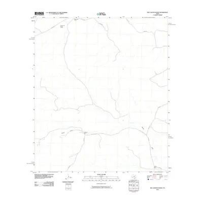
2010 Map of Big Canyon Ranch
USGS Topo · Published 2010About this map
Big Canyon Ranch and the associated Big Canyon Ranch Airport define the northern reaches of this Trans-Pecos landscape. In this arid cattle-ranching territory, the map reveals a network of unpaved roads and drainage features that dictate the movement of both livestock and vehicles. The ephemeral Downie Draw cuts across the southern portion of the sheet, providing a geographic focal point for the surrounding Hagelstein Ranch and Dudley Ranch. The road network, including Brown Rd and Dudley Ranch Rd, follows the natural contours of the draws, illustrating the critical relationship between topography and transportation in this sparsely populated region of Pecos County. The isolated airstrip and scattered ranch houses suggest a late-century reliance on long-distance travel and aviation to maintain these remote agricultural operations.
Find a feature on this map
13 named features on this map. Tap any name to fly to it.
Don’t see what you’re looking for? This feature index may not catch every label — zoom into the map to look around manually.
Map Details
Editions of this 2010 Big Canyon Ranch Map
This is the sole edition of this map. No revisions or reprints were ever made.
Other maps of this area

1928 · Sanderson
USGS Topo · 1:125,000

1954 · Fort Stockton
USGS Topo · 1:250,000

1958 · Fort Stockton
USGS Topo · 1:250,000

1969 · Circle Dot Ranch
USGS Topo · 1:24,000

1969 · Sanderson
USGS Topo · 1:24,000

1969 · Big Canyon Ranch
USGS Topo · 1:24,000

1969 · Big Canyon Ranch NW
USGS Topo · 1:24,000
1969 · Big Canyon Ranch SW
USGS Topo · 1:24,000

1969 · Dryden NW
USGS Topo · 1:24,000
1969 · Sanderson NE
USGS Topo · 1:24,000