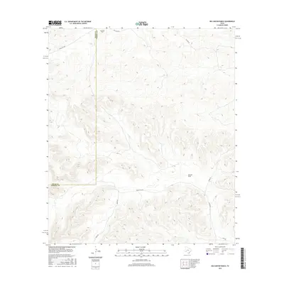
2016 Map of Big Canyon Ranch
USGS Topo · Published 2016About this map
Big Canyon Ranch sits along the northwestern edge of this landscape, marking a remote outpost in the Trans-Pecos region where the border between Pecos and Terrell Counties bisects the high desert. The terrain is defined by the significant hydrological feature of Downie Draw, which cuts through the canyon country. A network of private and ranch roads provide the only access across the deep contours of the area, including Dudley Ranch RD and Brown RD. These transportation routes, such as Walker Rd and Huckaby Rd, trace the natural pathways through the complex topography. This 2016 survey illustrates the persistent ranching footprint in a part of West Texas where land use is dictated by the rugged elevation changes and drainage patterns of the Stockton Plateau.
Find a feature on this map
11 named features on this map. Tap any name to fly to it.
Don’t see what you’re looking for? This feature index may not catch every label — zoom into the map to look around manually.
Map Details
Editions of this 2016 Big Canyon Ranch Map
This is the sole edition of this map. No revisions or reprints were ever made.
Other maps of this area

1928 · Sanderson
USGS Topo · 1:125,000

1954 · Fort Stockton
USGS Topo · 1:250,000

1958 · Fort Stockton
USGS Topo · 1:250,000

1969 · Circle Dot Ranch
USGS Topo · 1:24,000

1969 · Sanderson
USGS Topo · 1:24,000

1969 · Big Canyon Ranch
USGS Topo · 1:24,000

1969 · Big Canyon Ranch NW
USGS Topo · 1:24,000
1969 · Big Canyon Ranch SW
USGS Topo · 1:24,000

1969 · Dryden NW
USGS Topo · 1:24,000
1969 · Sanderson NE
USGS Topo · 1:24,000