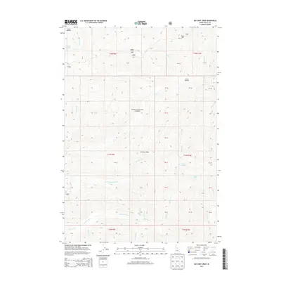
2013 Map of Big Chief Creek
USGS Topo · Published 2013About this map
Boise National Forest encompasses this high-elevation interior landscape in Valley County, where the drainage patterns of several critical tributaries are mapped in detail. The terrain is defined by the massive Big Baldy Ridge and prominent summits like Indian Creek Point and Mule Hill. Water moves across the quadrangle through a complex network of streams including Big Chief Creek, Little Pistol Creek, and Springfield Creek.
Find a feature on this map
29 named features on this map. Tap any name to fly to it.
Don’t see what you’re looking for? This feature index may not catch every label — zoom into the map to look around manually.
Map Details
Editions of this 2013 Big Chief Creek Map
This is the sole edition of this map. No revisions or reprints were ever made.
Other maps of this area

1937 · Yellow Pine
USGS Topo · 1:48,000

1943 · Yellow Pine
USGS Topo · 1:62,500

1957 · Challis
USGS Topo · 1:250,000

1960 · Challis
USGS Topo · 1:250,000

1961 · Greyhound Ridge
USGS Topo · 1:62,500

1961 · Chinook Mtn
USGS Topo · 1:62,500

1963 · Challis
USGS Topo · 1:250,000
1973 · Rainbow Peak
USGS Topo · 1:24,000
1973 · Big Chief Creek
USGS Topo · 1:24,000
1973 · Big Baldy
USGS Topo · 1:24,000