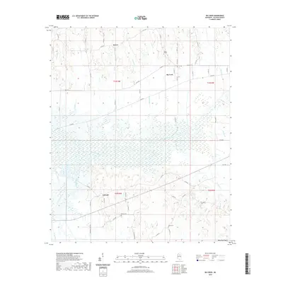
2020 Map of Big Creek
USGS Topo · Published 2020About this map
The Yalobusha River basin dominates this Calhoun County landscape, creating a wide alluvial plain known locally as Shipp Bottom in the eastern portion of the survey. Small agricultural settlements like Big Creek and Sabougla are connected by a network of rural roads such as W Main St and Old Gauley Rd. The topography is defined by the numerous tributaries feeding the river system, including Sabougla Creek, Lickup Cr, and Gaines Cr. Family and community history is preserved at sites like Chapel Hill Cem near the northern border and Magness Cem further south. This area reflects a quiet, rural continuity, where traditional land divisions such as T23N R8E persist alongside established townships like Slate Springs at the southeastern edge.
Find a feature on this map
66 named features on this map. Tap any name to fly to it.
Don’t see what you’re looking for? This feature index may not catch every label — zoom into the map to look around manually.
Map Details
Editions of this 2020 Big Creek Map
This is the sole edition of this map. No revisions or reprints were ever made.
Other maps of this area

1953 · Walthall
USGS Topo · 1:62,500

1953 · West Point
USGS Topo · 1:250,000

1954 · Pittsboro
USGS Topo · 1:62,500

1954 · Duck Hill
USGS Topo · 1:62,500

1955 · Coffeeville
USGS Topo · 1:62,500

1958 · West Point
USGS Topo · 1:250,000

1963 · West Point
USGS Topo · 1:250,000
1976 · Pittsboro SE
USGS Topo · 1:24,000
1976 · Pittsboro NE
USGS Topo · 1:24,000
1976 · Walthall NE
USGS Topo · 1:24,000