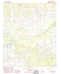
1983 Map of Big Creek
USGS Topo · Published 1984About this map
Indian Treaty Boundary Line cuts diagonally across this portion of Calhoun County, Mississippi, marking a significant historical demarcation in the regional landscape. The Yalobusha River and the Topashaw Creek Canal dominate the central drainage, creating a complex wetland environment now preserved through the Grenada State Waterfowl Management Area and the Upper Yalobusha Public Use Area.
Find a feature on this map
27 named features on this map. Tap any name to fly to it.
Don’t see what you’re looking for? This feature index may not catch every label — zoom into the map to look around manually.
Map Details
Editions of this 1983 Big Creek Map
This is the sole edition of this map. No revisions or reprints were ever made.
Other maps of this area

1953 · Walthall
USGS Topo · 1:62,500

1953 · West Point
USGS Topo · 1:250,000

1954 · Pittsboro
USGS Topo · 1:62,500

1954 · Duck Hill
USGS Topo · 1:62,500

1955 · Coffeeville
USGS Topo · 1:62,500

1958 · West Point
USGS Topo · 1:250,000

1963 · West Point
USGS Topo · 1:250,000
1976 · Pittsboro SE
USGS Topo · 1:24,000
1976 · Pittsboro NE
USGS Topo · 1:24,000
1976 · Walthall NE
USGS Topo · 1:24,000