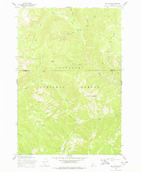
1969 Map of Big Creek
USGS Topo · Published 1978About this map
Golden Hand Mine and the Werdenhoff Mine punctuate this high-altitude landscape within the Payette National Forest, reflecting the lode mining activity that once defined these remote ridges. The 1969 field-checked data captures a transition between the area's prospecting history and its role as a recreational and administrative hub. Along the valley floor, the Big Creek settlement features a Ranger Station, Campground, and a critical Landing Strip serving the backcountry. High-elevation landmarks like Ramey Ridge and Pueblo Summit overlook a dense network of watercourses, including Beaver Creek and Smith Creek, while various Pack Trails provide the only overland access between isolated outposts like Hand Camp and the Mahan Cabin. This survey is a detailed record of the rugged intersection where Idaho and Valley Counties meet amidst the drainage of the West Fork and Little Big Creek.
Find a feature on this map
34 named features on this map. Tap any name to fly to it.
Don’t see what you’re looking for? This feature index may not catch every label — zoom into the map to look around manually.
Map Details
Editions of this 1969 Big Creek Map
2 editions found
Other maps of this area

1937 · Big Creek
USGS Topo · 1:48,000

1942 · Big Creek
USGS Topo · 1:62,500

1956 · Elk City
USGS Topo · 1:250,000

1960 · Elk City
USGS Topo · 1:250,000

1969 · Edwardsburg
USGS Topo · 1:24,000

1969 · Profile Gap
USGS Topo · 1:24,000

1969 · Wolf Fang Peak
USGS Topo · 1:24,000

1969 · Big Creek
USGS Topo · 1:24,000

1973 · Center Mtn
USGS Topo · 1:24,000

1973 · Bismark Mtn
USGS Topo · 1:24,000