
1952 Map of Big Delta A-5
USGS Topo · Published 1952About this map
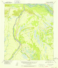
The Tanana River and the braided path of Delta Creek dominate this 1952 topographic study of the Alaskan interior south of Fairbanks. The landscape is defined by its vast water networks and the early infrastructure of the Richardson Highway, which cuts across the northeast corner of the sheet near Mile 286. Evidence of human presence is sparse and temporary, limited to a small Cabin and a group of Cabins situated near the headwaters of Clear Creek. This map captures a moment in the mid-twentieth century when the region remained largely undeveloped, centered on the logistical lifeline of the highway and the natural flow of the major river systems. The detailed contouring reveals the subtle transitions between the low-lying river plains and the rising terrain characterized by points like Top and Low.
Find a feature on this map
9 named features on this map. Tap any name to fly to it.
Don’t see what you’re looking for? This feature index may not catch every label — zoom into the map to look around manually.
Map Details
Editions of this 1952 Big Delta A-5 Map
2 editions found
Historical Maps of Unorganized Borough Through Time
634 maps found

1899 Fortymile
Southeast Fairbanks Borough, AK

1948 Tanacross A-3
Southeast Fairbanks Borough, AK

1948 Tanacross A-4
Southeast Fairbanks Borough, AK

1948 Tanacross A-5
Southeast Fairbanks Borough, AK

1948 Tanacross A-6
Southeast Fairbanks Borough, AK

1948 Tanacross B-3
Southeast Fairbanks Borough, AK

1948 Tanacross B-5
Southeast Fairbanks Borough, AK

1949 Big Delta A-6
Southeast Fairbanks Borough, AK

1949 Tanacross A-5
Southeast Fairbanks Borough, AK

1949 Tanacross B-3
Southeast Fairbanks Borough, AK

1949 Tanacross B-4
Southeast Fairbanks Borough, AK

1949 Tanacross B-6
Southeast Fairbanks Borough, AK

1950 Big Delta A-4
Southeast Fairbanks Borough, AK

1950 Big Delta A-5
Southeast Fairbanks Borough, AK

1950 Big Delta B-4
Southeast Fairbanks Borough, AK

1950 Mount Hayes D-5
Southeast Fairbanks Borough, AK

1950 Mount Hayes D-6
Southeast Fairbanks Borough, AK

1950 Mount Hayes
Southeast Fairbanks Borough, AK

1950 Mt. Hayes C-4
Southeast Fairbanks Borough, AK

1950 Mt. Hayes D-1
Southeast Fairbanks Borough, AK

1951 Big Delta A-6
Southeast Fairbanks Borough, AK

1951 Mount Hayes C-5
Southeast Fairbanks Borough, AK

1951 Mount Hayes C-6
Southeast Fairbanks Borough, AK

1951 Mount Hayes
Southeast Fairbanks Borough, AK

1951 Tanacross B-4
Southeast Fairbanks Borough, AK

1951 Tanacross B-6
Southeast Fairbanks Borough, AK

1952 Big Delta A-4
Southeast Fairbanks Borough, AK
1952 Big Delta A-5
Southeast Fairbanks Borough, AK

1952 Mt. Hayes C-4
Southeast Fairbanks Borough, AK

1952 Mt. Hayes D-4
Southeast Fairbanks Borough, AK

1952 Mt. Hayes D-5
Southeast Fairbanks Borough, AK

1952 Mt. Hayes D-6
Southeast Fairbanks Borough, AK

1952 Nabesna D-1
Southeast Fairbanks Borough, AK

1952 Tanacross A-1
Southeast Fairbanks Borough, AK

1952 Tanacross A-3
Southeast Fairbanks Borough, AK

1952 Tanacross A-4
Southeast Fairbanks Borough, AK

1952 Tanacross A-5
Southeast Fairbanks Borough, AK

1952 Tanacross A-6
Southeast Fairbanks Borough, AK

1952 Tanacross B-3
Southeast Fairbanks Borough, AK

1952 Tanacross B-5
Southeast Fairbanks Borough, AK

1953 Big Delta B-4
Southeast Fairbanks Borough, AK

1954 Big Delta A-2
Southeast Fairbanks Borough, AK

1954 Mount Hayes C-1
Southeast Fairbanks Borough, AK

1954 Mount Hayes C-3
Southeast Fairbanks Borough, AK

1954 Mount Hayes D-2
Southeast Fairbanks Borough, AK

1954 Mount Hayes D-3
Southeast Fairbanks Borough, AK

1954 Mt. Hayes D-1
Southeast Fairbanks Borough, AK

1954 Nabesna C-3
Southeast Fairbanks Borough, AK

1954 Nabesna D-2
Southeast Fairbanks Borough, AK

1954 Nabesna D-3
Southeast Fairbanks Borough, AK

1954 Nabesna D-4
Southeast Fairbanks Borough, AK

1954 Tanacross A-2
Southeast Fairbanks Borough, AK

1954 Tanacross C-6
Southeast Fairbanks Borough, AK

1954 Tanacross D-6
Southeast Fairbanks Borough, AK

1955 Big Delta A-1
Southeast Fairbanks Borough, AK

1955 Big Delta A-2
Southeast Fairbanks Borough, AK

1955 Big Delta A-3
Southeast Fairbanks Borough, AK

1955 Mount Hayes C-1
Southeast Fairbanks Borough, AK

1955 Mount Hayes C-2
Southeast Fairbanks Borough, AK

1955 Mount Hayes C-3
Southeast Fairbanks Borough, AK

1955 Mount Hayes D-2
Southeast Fairbanks Borough, AK

1955 Mount Hayes
Southeast Fairbanks Borough, AK

1955 Mt. Hayes D-3
Southeast Fairbanks Borough, AK

1955 Nabesna C-1
Southeast Fairbanks Borough, AK

1955 Nabesna C-2
Southeast Fairbanks Borough, AK

1955 Nabesna C-3
Southeast Fairbanks Borough, AK

1955 Nabesna D-2
Southeast Fairbanks Borough, AK

1955 Nabesna D-3
Southeast Fairbanks Borough, AK

1955 Tanacross A-2
Southeast Fairbanks Borough, AK

1955 Tanacross C-6
Southeast Fairbanks Borough, AK

1955 Tanacross D-6
Southeast Fairbanks Borough, AK

1956 Charley River A-1
Southeast Fairbanks Borough, AK

1956 Charley River A-2
Southeast Fairbanks Borough, AK

1956 Charley River A-3
Southeast Fairbanks Borough, AK

1956 Charley River A-4
Southeast Fairbanks Borough, AK

1956 Charley River B-1
Southeast Fairbanks Borough, AK

1956 Charley River B-2
Southeast Fairbanks Borough, AK

1956 Charley River B-3
Southeast Fairbanks Borough, AK

1956 Charley River C-1
Southeast Fairbanks Borough, AK

1956 Eagle A-1
Southeast Fairbanks Borough, AK

1956 Eagle A-2
Southeast Fairbanks Borough, AK

1956 Eagle A-4
Southeast Fairbanks Borough, AK

1956 Eagle A-5
Southeast Fairbanks Borough, AK

1956 Eagle A-6
Southeast Fairbanks Borough, AK

1956 Eagle B-1
Southeast Fairbanks Borough, AK

1956 Eagle B-2
Southeast Fairbanks Borough, AK

1956 Eagle B-3
Southeast Fairbanks Borough, AK

1956 Eagle B-4
Southeast Fairbanks Borough, AK

1956 Eagle B-5
Southeast Fairbanks Borough, AK

1956 Eagle B-6
Southeast Fairbanks Borough, AK

1956 Eagle C-1
Southeast Fairbanks Borough, AK

1956 Eagle C-2
Southeast Fairbanks Borough, AK

1956 Eagle C-3
Southeast Fairbanks Borough, AK

1956 Eagle C-4
Southeast Fairbanks Borough, AK

1956 Eagle C-5
Southeast Fairbanks Borough, AK

1956 Eagle C-6
Southeast Fairbanks Borough, AK

1956 Eagle D-1
Southeast Fairbanks Borough, AK

1956 Eagle D-2
Southeast Fairbanks Borough, AK

1956 Eagle D-3
Southeast Fairbanks Borough, AK

1956 Eagle D-4
Southeast Fairbanks Borough, AK

1956 Eagle D-5
Southeast Fairbanks Borough, AK

1956 Tanacross B-1
Southeast Fairbanks Borough, AK

1956 Tanacross B-2
Southeast Fairbanks Borough, AK

1956 Tanacross C-1
Southeast Fairbanks Borough, AK

1956 Tanacross C-2
Southeast Fairbanks Borough, AK

1956 Tanacross C-3
Southeast Fairbanks Borough, AK

1956 Tanacross C-4
Southeast Fairbanks Borough, AK

1956 Tanacross C-5
Southeast Fairbanks Borough, AK

1956 Tanacross D-1
Southeast Fairbanks Borough, AK

1956 Tanacross D-2
Southeast Fairbanks Borough, AK

1956 Tanacross D-3
Southeast Fairbanks Borough, AK

1956 Tanacross D-4
Southeast Fairbanks Borough, AK

1956 Tanacross D-5
Southeast Fairbanks Borough, AK

1957 Eagle A-3
Southeast Fairbanks Borough, AK

1958 Big Delta B-1
Southeast Fairbanks Borough, AK

1958 Big Delta B-2
Southeast Fairbanks Borough, AK

1958 Big Delta B-3
Southeast Fairbanks Borough, AK

1958 Big Delta C-1
Southeast Fairbanks Borough, AK

1959 Big Delta A-4
Southeast Fairbanks Borough, AK

1959 Nabesna A-1
Southeast Fairbanks Borough, AK

1960 Nabesna A-2
Southeast Fairbanks Borough, AK

1960 Nabesna B-1
Southeast Fairbanks Borough, AK

1960 Nabesna B-2
Southeast Fairbanks Borough, AK

1960 Nabesna D-4
Southeast Fairbanks Borough, AK

1962 Big Delta A-4
Southeast Fairbanks Borough, AK

2013 Big Delta A-5 SE
Southeast Fairbanks Borough, AK

2013 Big Delta A-5 SW
Southeast Fairbanks Borough, AK

2013 Mount Hayes D-1 NE
Southeast Fairbanks Borough, AK

2013 Mount Hayes D-5 NE
Southeast Fairbanks Borough, AK

2013 Mount Hayes D-5 NW
Southeast Fairbanks Borough, AK

2013 Nabesna C-1 NE
Southeast Fairbanks Borough, AK

2013 Nabesna D-1 NE
Southeast Fairbanks Borough, AK

2013 Nabesna D-1 SE
Southeast Fairbanks Borough, AK

2013 Tanacross A-1 NE
Southeast Fairbanks Borough, AK

2013 Tanacross A-1 NW
Southeast Fairbanks Borough, AK

2013 Tanacross A-1 SE
Southeast Fairbanks Borough, AK

2013 Tanacross A-1 SW
Southeast Fairbanks Borough, AK

2013 Tanacross A-2 NE
Southeast Fairbanks Borough, AK

2013 Tanacross A-2 NW
Southeast Fairbanks Borough, AK

2013 Tanacross A-2 SE
Southeast Fairbanks Borough, AK

2013 Tanacross A-2 SW
Southeast Fairbanks Borough, AK

2013 Tanacross A-3 NE
Southeast Fairbanks Borough, AK

2013 Tanacross A-3 SE
Southeast Fairbanks Borough, AK

2013 Tanacross B-2 NW
Southeast Fairbanks Borough, AK

2013 Tanacross B-2 SW
Southeast Fairbanks Borough, AK

2013 Tanacross B-3 NE
Southeast Fairbanks Borough, AK

2013 Tanacross B-3 SE
Southeast Fairbanks Borough, AK

2013 Tanacross C-2 NE
Southeast Fairbanks Borough, AK

2013 Tanacross C-2 NW
Southeast Fairbanks Borough, AK

2013 Tanacross C-2 SE
Southeast Fairbanks Borough, AK

2013 Tanacross C-2 SW
Southeast Fairbanks Borough, AK

2013 Tanacross C-3 NE
Southeast Fairbanks Borough, AK

2013 Tanacross C-3 NW
Southeast Fairbanks Borough, AK

2013 Tanacross C-3 SE
Southeast Fairbanks Borough, AK

2013 Tanacross C-3 SW
Southeast Fairbanks Borough, AK

2013 Tanacross C-4 NE
Southeast Fairbanks Borough, AK

2013 Tanacross C-4 NW
Southeast Fairbanks Borough, AK

2013 Tanacross C-4 SE
Southeast Fairbanks Borough, AK

2013 Tanacross C-4 SW
Southeast Fairbanks Borough, AK

2013 Tanacross C-5 NE
Southeast Fairbanks Borough, AK

2013 Tanacross C-5 SE
Southeast Fairbanks Borough, AK

2013 Tanacross D-1 NE
Southeast Fairbanks Borough, AK

2013 Tanacross D-1 NW
Southeast Fairbanks Borough, AK

2013 Tanacross D-2 NE
Southeast Fairbanks Borough, AK

2013 Tanacross D-2 NW
Southeast Fairbanks Borough, AK

2013 Tanacross D-2 SE
Southeast Fairbanks Borough, AK

2013 Tanacross D-2 SW
Southeast Fairbanks Borough, AK

2013 Tanacross D-3 NE
Southeast Fairbanks Borough, AK

2013 Tanacross D-3 NW
Southeast Fairbanks Borough, AK

2013 Tanacross D-3 SE
Southeast Fairbanks Borough, AK

2013 Tanacross D-3 SW
Southeast Fairbanks Borough, AK

2013 Tanacross D-4 NE
Southeast Fairbanks Borough, AK

2013 Tanacross D-4 NW
Southeast Fairbanks Borough, AK

2013 Tanacross D-4 SE
Southeast Fairbanks Borough, AK

2013 Tanacross D-4 SW
Southeast Fairbanks Borough, AK

2013 Tanacross D-5 NE
Southeast Fairbanks Borough, AK

2013 Tanacross D-5 NW
Southeast Fairbanks Borough, AK

2013 Tanacross D-5 SE
Southeast Fairbanks Borough, AK

2013 Tanacross D-6 NE
Southeast Fairbanks Borough, AK

2013 Tanacross D-6 NW
Southeast Fairbanks Borough, AK

2015 Tanacross B-1 NE
Southeast Fairbanks Borough, AK

2015 Tanacross B-1 NW
Southeast Fairbanks Borough, AK

2015 Tanacross B-1 SE
Southeast Fairbanks Borough, AK

2015 Tanacross B-1 SW
Southeast Fairbanks Borough, AK

2015 Tanacross B-2 NE
Southeast Fairbanks Borough, AK

2015 Tanacross B-2 SE
Southeast Fairbanks Borough, AK

2015 Tanacross C-1 NE
Southeast Fairbanks Borough, AK

2015 Tanacross C-1 NW
Southeast Fairbanks Borough, AK

2015 Tanacross C-1 SE
Southeast Fairbanks Borough, AK

2015 Tanacross C-1 SW
Southeast Fairbanks Borough, AK

2015 Tanacross D-1 SE
Southeast Fairbanks Borough, AK

2015 Tanacross D-1 SW
Southeast Fairbanks Borough, AK

2016 Big Delta A-3 NE
Southeast Fairbanks Borough, AK

2016 Big Delta A-3 NW
Southeast Fairbanks Borough, AK

2016 Big Delta A-3 SE
Southeast Fairbanks Borough, AK

2016 Big Delta A-3 SW
Southeast Fairbanks Borough, AK

2016 Big Delta A-4 NE
Southeast Fairbanks Borough, AK

2016 Big Delta A-4 NW
Southeast Fairbanks Borough, AK

2016 Big Delta A-4 SE
Southeast Fairbanks Borough, AK

2016 Big Delta A-4 SW
Southeast Fairbanks Borough, AK

2016 Big Delta A-5 NE
Southeast Fairbanks Borough, AK

2016 Big Delta A-5 NW
Southeast Fairbanks Borough, AK

2016 Big Delta A-6 NE
Southeast Fairbanks Borough, AK

2016 Big Delta A-6 NW
Southeast Fairbanks Borough, AK

2016 Big Delta A-6 SE
Southeast Fairbanks Borough, AK

2016 Big Delta A-6 SW
Southeast Fairbanks Borough, AK

2016 Big Delta B-3 NE
Southeast Fairbanks Borough, AK

2016 Big Delta B-3 NW
Southeast Fairbanks Borough, AK

2016 Big Delta B-3 SE
Southeast Fairbanks Borough, AK

2016 Big Delta B-3 SW
Southeast Fairbanks Borough, AK

2016 Big Delta B-4 NE
Southeast Fairbanks Borough, AK

2016 Big Delta B-4 NW
Southeast Fairbanks Borough, AK

2016 Big Delta B-4 SE
Southeast Fairbanks Borough, AK

2016 Big Delta B-4 SW
Southeast Fairbanks Borough, AK

2016 Big Delta B-5 SE
Southeast Fairbanks Borough, AK

2016 Mount Hayes C-1 NE
Southeast Fairbanks Borough, AK

2016 Mount Hayes C-1 NW
Southeast Fairbanks Borough, AK

2016 Mount Hayes C-1 SE
Southeast Fairbanks Borough, AK

2016 Mount Hayes C-1 SW
Southeast Fairbanks Borough, AK

2016 Mount Hayes C-2 NE
Southeast Fairbanks Borough, AK

2016 Mount Hayes C-2 NW
Southeast Fairbanks Borough, AK

2016 Mount Hayes C-2 SE
Southeast Fairbanks Borough, AK

2016 Mount Hayes C-2 SW
Southeast Fairbanks Borough, AK

2016 Mount Hayes C-3 NE
Southeast Fairbanks Borough, AK

2016 Mount Hayes C-3 NW
Southeast Fairbanks Borough, AK

2016 Mount Hayes C-3 SE
Southeast Fairbanks Borough, AK

2016 Mount Hayes C-3 SW
Southeast Fairbanks Borough, AK

2016 Mount Hayes C-4 NE
Southeast Fairbanks Borough, AK

2016 Mount Hayes C-4 NW
Southeast Fairbanks Borough, AK

2016 Mount Hayes C-4 SE
Southeast Fairbanks Borough, AK

2016 Mount Hayes C-4 SW
Southeast Fairbanks Borough, AK

2016 Mount Hayes C-5 NE
Southeast Fairbanks Borough, AK

2016 Mount Hayes C-5 NW
Southeast Fairbanks Borough, AK

2016 Mount Hayes C-5 SE
Southeast Fairbanks Borough, AK

2016 Mount Hayes C-5 SW
Southeast Fairbanks Borough, AK

2016 Mount Hayes C-6 NE
Southeast Fairbanks Borough, AK

2016 Mount Hayes C-6 NW
Southeast Fairbanks Borough, AK

2016 Mount Hayes D-1 NW
Southeast Fairbanks Borough, AK

2016 Mount Hayes D-1 SE
Southeast Fairbanks Borough, AK

2016 Mount Hayes D-1 SW
Southeast Fairbanks Borough, AK

2016 Mount Hayes D-2 NE
Southeast Fairbanks Borough, AK

2016 Mount Hayes D-2 NW
Southeast Fairbanks Borough, AK

2016 Mount Hayes D-2 SE
Southeast Fairbanks Borough, AK

2016 Mount Hayes D-2 SW
Southeast Fairbanks Borough, AK

2016 Mount Hayes D-3 NE
Southeast Fairbanks Borough, AK

2016 Mount Hayes D-3 NW
Southeast Fairbanks Borough, AK

2016 Mount Hayes D-3 SE
Southeast Fairbanks Borough, AK

2016 Mount Hayes D-3 SW
Southeast Fairbanks Borough, AK

2016 Mount Hayes D-4 NE
Southeast Fairbanks Borough, AK

2016 Mount Hayes D-4 NW
Southeast Fairbanks Borough, AK

2016 Mount Hayes D-4 SE
Southeast Fairbanks Borough, AK

2016 Mount Hayes D-4 SW
Southeast Fairbanks Borough, AK

2016 Mount Hayes D-5 SE
Southeast Fairbanks Borough, AK

2016 Mount Hayes D-5 SW
Southeast Fairbanks Borough, AK

2016 Mount Hayes D-6 NE
Southeast Fairbanks Borough, AK

2016 Mount Hayes D-6 NW
Southeast Fairbanks Borough, AK

2016 Mount Hayes D-6 SE
Southeast Fairbanks Borough, AK

2016 Mount Hayes D-6 SW
Southeast Fairbanks Borough, AK

2016 Nabesna A-1 NE
Southeast Fairbanks Borough, AK

2016 Nabesna A-1 NW
Southeast Fairbanks Borough, AK

2016 Nabesna A-1 SE
Southeast Fairbanks Borough, AK

2016 Nabesna A-1 SW
Southeast Fairbanks Borough, AK

2016 Nabesna A-2 NE
Southeast Fairbanks Borough, AK

2016 Nabesna A-2 NW
Southeast Fairbanks Borough, AK

2016 Nabesna A-2 SE
Southeast Fairbanks Borough, AK

2016 Nabesna B-1 NE
Southeast Fairbanks Borough, AK

2016 Nabesna B-1 NW
Southeast Fairbanks Borough, AK

2016 Nabesna B-1 SE
Southeast Fairbanks Borough, AK

2016 Nabesna B-1 SW
Southeast Fairbanks Borough, AK

2016 Nabesna B-2 NE
Southeast Fairbanks Borough, AK

2016 Nabesna B-2 NW
Southeast Fairbanks Borough, AK

2016 Nabesna B-2 SE
Southeast Fairbanks Borough, AK

2016 Nabesna B-2 SW
Southeast Fairbanks Borough, AK

2016 Nabesna C-1 NW
Southeast Fairbanks Borough, AK

2016 Nabesna C-1 SE
Southeast Fairbanks Borough, AK

2016 Nabesna C-1 SW
Southeast Fairbanks Borough, AK

2016 Nabesna C-2 NE
Southeast Fairbanks Borough, AK

2016 Nabesna C-2 NW
Southeast Fairbanks Borough, AK

2016 Nabesna C-2 SE
Southeast Fairbanks Borough, AK

2016 Nabesna C-2 SW
Southeast Fairbanks Borough, AK

2016 Nabesna C-3 NE
Southeast Fairbanks Borough, AK

2016 Nabesna C-3 NW
Southeast Fairbanks Borough, AK

2016 Nabesna C-3 SE
Southeast Fairbanks Borough, AK

2016 Nabesna C-4 NW
Southeast Fairbanks Borough, AK

2016 Nabesna D-1 SW
Southeast Fairbanks Borough, AK

2016 Nabesna D-2 NW
Southeast Fairbanks Borough, AK

2016 Nabesna D-2 SE
Southeast Fairbanks Borough, AK

2016 Nabesna D-2 SW
Southeast Fairbanks Borough, AK

2016 Nabesna D-3 NE
Southeast Fairbanks Borough, AK

2016 Nabesna D-3 NW
Southeast Fairbanks Borough, AK

2016 Nabesna D-3 SE
Southeast Fairbanks Borough, AK

2016 Nabesna D-3 SW
Southeast Fairbanks Borough, AK

2016 Nabesna D-4 NE
Southeast Fairbanks Borough, AK

2016 Nabesna D-4 NW
Southeast Fairbanks Borough, AK

2016 Nabesna D-4 SE
Southeast Fairbanks Borough, AK

2016 Nabesna D-4 SW
Southeast Fairbanks Borough, AK

2016 Tanacross A-3 NW
Southeast Fairbanks Borough, AK

2016 Tanacross A-3 SW
Southeast Fairbanks Borough, AK

2016 Tanacross A-4 NE
Southeast Fairbanks Borough, AK

2016 Tanacross A-4 NW
Southeast Fairbanks Borough, AK

2016 Tanacross A-4 SE
Southeast Fairbanks Borough, AK

2016 Tanacross A-4 SW
Southeast Fairbanks Borough, AK

2016 Tanacross A-5 NE
Southeast Fairbanks Borough, AK

2016 Tanacross A-5 NW
Southeast Fairbanks Borough, AK

2016 Tanacross A-6 NE
Southeast Fairbanks Borough, AK

2016 Tanacross A-6 NW
Southeast Fairbanks Borough, AK

2016 Tanacross B-3 NW
Southeast Fairbanks Borough, AK

2016 Tanacross B-3 SW
Southeast Fairbanks Borough, AK

2016 Tanacross B-4 NE
Southeast Fairbanks Borough, AK

2016 Tanacross B-4 NW
Southeast Fairbanks Borough, AK

2016 Tanacross B-4 SE
Southeast Fairbanks Borough, AK

2016 Tanacross B-4 SW
Southeast Fairbanks Borough, AK

2016 Tanacross B-5 NE
Southeast Fairbanks Borough, AK

2016 Tanacross B-5 NW
Southeast Fairbanks Borough, AK

2016 Tanacross B-5 SE
Southeast Fairbanks Borough, AK

2016 Tanacross B-5 SW
Southeast Fairbanks Borough, AK

2016 Tanacross B-6 NE
Southeast Fairbanks Borough, AK

2016 Tanacross B-6 NW
Southeast Fairbanks Borough, AK

2016 Tanacross B-6 SE
Southeast Fairbanks Borough, AK

2016 Tanacross B-6 SW
Southeast Fairbanks Borough, AK

2016 Tanacross C-5 NW
Southeast Fairbanks Borough, AK

2016 Tanacross C-5 SW
Southeast Fairbanks Borough, AK

2016 Tanacross C-6 NE
Southeast Fairbanks Borough, AK

2016 Tanacross C-6 NW
Southeast Fairbanks Borough, AK

2016 Tanacross C-6 SE
Southeast Fairbanks Borough, AK

2016 Tanacross C-6 SW
Southeast Fairbanks Borough, AK

2016 Tanacross D-5 SW
Southeast Fairbanks Borough, AK

2016 Tanacross D-6 SE
Southeast Fairbanks Borough, AK

2016 Tanacross D-6 SW
Southeast Fairbanks Borough, AK

2017 Nabesna D-1 NW
Southeast Fairbanks Borough, AK

2017 Nabesna D-2 NE
Southeast Fairbanks Borough, AK

2018 Big Delta A-1 NE
Southeast Fairbanks Borough, AK

2018 Big Delta A-1 NW
Southeast Fairbanks Borough, AK

2018 Big Delta A-1 SE
Southeast Fairbanks Borough, AK

2018 Big Delta A-1 SW
Southeast Fairbanks Borough, AK

2018 Big Delta A-2 NE
Southeast Fairbanks Borough, AK

2018 Big Delta A-2 NW
Southeast Fairbanks Borough, AK

2018 Big Delta A-2 SE
Southeast Fairbanks Borough, AK

2018 Big Delta A-2 SW
Southeast Fairbanks Borough, AK

2018 Big Delta B-1 NE
Southeast Fairbanks Borough, AK

2018 Big Delta B-1 NW
Southeast Fairbanks Borough, AK

2018 Big Delta B-1 SE
Southeast Fairbanks Borough, AK

2018 Big Delta B-1 SW
Southeast Fairbanks Borough, AK

2018 Big Delta B-2 NE
Southeast Fairbanks Borough, AK

2018 Big Delta B-2 NW
Southeast Fairbanks Borough, AK

2018 Big Delta B-2 SE
Southeast Fairbanks Borough, AK

2018 Big Delta B-2 SW
Southeast Fairbanks Borough, AK

2018 Big Delta C-1 SE
Southeast Fairbanks Borough, AK

2018 Big Delta C-1 SW
Southeast Fairbanks Borough, AK

2018 Big Delta C-2 SE
Southeast Fairbanks Borough, AK

2018 Big Delta C-2 SW
Southeast Fairbanks Borough, AK

2018 Charley River A-1 NE
Southeast Fairbanks Borough, AK

2018 Charley River A-1 NW
Southeast Fairbanks Borough, AK

2018 Charley River A-1 SE
Southeast Fairbanks Borough, AK

2018 Charley River A-1 SW
Southeast Fairbanks Borough, AK

2018 Charley River A-2 NE
Southeast Fairbanks Borough, AK

2018 Charley River A-2 NW
Southeast Fairbanks Borough, AK

2018 Charley River A-2 SE
Southeast Fairbanks Borough, AK

2018 Charley River A-2 SW
Southeast Fairbanks Borough, AK

2018 Charley River A-3 NE
Southeast Fairbanks Borough, AK

2018 Charley River A-3 NW
Southeast Fairbanks Borough, AK

2018 Charley River A-3 SE
Southeast Fairbanks Borough, AK

2018 Charley River A-3 SW
Southeast Fairbanks Borough, AK

2018 Charley River A-4 NE
Southeast Fairbanks Borough, AK

2018 Charley River A-4 SE
Southeast Fairbanks Borough, AK

2018 Charley River A-4 SW
Southeast Fairbanks Borough, AK

2018 Charley River A-5 SE
Southeast Fairbanks Borough, AK

2018 Charley River B-1 NE
Southeast Fairbanks Borough, AK

2018 Charley River B-1 NW
Southeast Fairbanks Borough, AK

2018 Charley River B-1 SE
Southeast Fairbanks Borough, AK

2018 Charley River B-1 SW
Southeast Fairbanks Borough, AK

2018 Charley River B-2 NE
Southeast Fairbanks Borough, AK

2018 Charley River B-2 NW
Southeast Fairbanks Borough, AK

2018 Charley River B-2 SE
Southeast Fairbanks Borough, AK

2018 Charley River B-2 SW
Southeast Fairbanks Borough, AK

2018 Charley River B-3 NE
Southeast Fairbanks Borough, AK

2018 Charley River B-3 SE
Southeast Fairbanks Borough, AK

2018 Charley River B-3 SW
Southeast Fairbanks Borough, AK

2018 Charley River B-4 SE
Southeast Fairbanks Borough, AK

2018 Charley River C-1 NE
Southeast Fairbanks Borough, AK

2018 Charley River C-1 SE
Southeast Fairbanks Borough, AK

2018 Charley River C-1 SW
Southeast Fairbanks Borough, AK

2018 Charley River D-1 SE
Southeast Fairbanks Borough, AK

2018 Eagle A-1 NE
Southeast Fairbanks Borough, AK

2018 Eagle A-1 NW
Southeast Fairbanks Borough, AK

2018 Eagle A-1 SE
Southeast Fairbanks Borough, AK

2018 Eagle A-1 SW
Southeast Fairbanks Borough, AK

2018 Eagle A-2 NE
Southeast Fairbanks Borough, AK

2018 Eagle A-2 NW
Southeast Fairbanks Borough, AK

2018 Eagle A-2 SE
Southeast Fairbanks Borough, AK

2018 Eagle A-2 SW
Southeast Fairbanks Borough, AK

2018 Eagle A-3 NE
Southeast Fairbanks Borough, AK

2018 Eagle A-3 NW
Southeast Fairbanks Borough, AK

2018 Eagle A-3 SE
Southeast Fairbanks Borough, AK

2018 Eagle A-3 SW
Southeast Fairbanks Borough, AK

2018 Eagle A-4 NE
Southeast Fairbanks Borough, AK

2018 Eagle A-4 NW
Southeast Fairbanks Borough, AK

2018 Eagle A-4 SE
Southeast Fairbanks Borough, AK

2018 Eagle A-4 SW
Southeast Fairbanks Borough, AK

2018 Eagle A-5 NE
Southeast Fairbanks Borough, AK

2018 Eagle A-5 NW
Southeast Fairbanks Borough, AK

2018 Eagle A-5 SE
Southeast Fairbanks Borough, AK

2018 Eagle A-5 SW
Southeast Fairbanks Borough, AK

2018 Eagle A-6 NE
Southeast Fairbanks Borough, AK

2018 Eagle A-6 NW
Southeast Fairbanks Borough, AK

2018 Eagle A-6 SE
Southeast Fairbanks Borough, AK

2018 Eagle A-6 SW
Southeast Fairbanks Borough, AK

2018 Eagle B-1 NE
Southeast Fairbanks Borough, AK

2018 Eagle B-1 NW
Southeast Fairbanks Borough, AK

2018 Eagle B-1 SE
Southeast Fairbanks Borough, AK

2018 Eagle B-1 SW
Southeast Fairbanks Borough, AK

2018 Eagle B-2 NE
Southeast Fairbanks Borough, AK

2018 Eagle B-2 NW
Southeast Fairbanks Borough, AK

2018 Eagle B-2 SE
Southeast Fairbanks Borough, AK

2018 Eagle B-2 SW
Southeast Fairbanks Borough, AK

2018 Eagle B-3 NE
Southeast Fairbanks Borough, AK

2018 Eagle B-3 NW
Southeast Fairbanks Borough, AK

2018 Eagle B-3 SE
Southeast Fairbanks Borough, AK

2018 Eagle B-3 SW
Southeast Fairbanks Borough, AK

2018 Eagle B-4 NE
Southeast Fairbanks Borough, AK

2018 Eagle B-4 NW
Southeast Fairbanks Borough, AK

2018 Eagle B-4 SE
Southeast Fairbanks Borough, AK

2018 Eagle B-4 SW
Southeast Fairbanks Borough, AK

2018 Eagle B-5 NE
Southeast Fairbanks Borough, AK

2018 Eagle B-5 NW
Southeast Fairbanks Borough, AK

2018 Eagle B-5 SE
Southeast Fairbanks Borough, AK

2018 Eagle B-5 SW
Southeast Fairbanks Borough, AK

2018 Eagle B-6 NE
Southeast Fairbanks Borough, AK

2018 Eagle B-6 NW
Southeast Fairbanks Borough, AK

2018 Eagle B-6 SE
Southeast Fairbanks Borough, AK

2018 Eagle B-6 SW
Southeast Fairbanks Borough, AK

2018 Eagle C-1 NE
Southeast Fairbanks Borough, AK

2018 Eagle C-1 NW
Southeast Fairbanks Borough, AK

2018 Eagle C-1 SE
Southeast Fairbanks Borough, AK

2018 Eagle C-1 SW
Southeast Fairbanks Borough, AK

2018 Eagle C-2 NE
Southeast Fairbanks Borough, AK

2018 Eagle C-2 NW
Southeast Fairbanks Borough, AK

2018 Eagle C-2 SE
Southeast Fairbanks Borough, AK

2018 Eagle C-2 SW
Southeast Fairbanks Borough, AK

2018 Eagle C-3 NE
Southeast Fairbanks Borough, AK

2018 Eagle C-3 NW
Southeast Fairbanks Borough, AK

2018 Eagle C-3 SE
Southeast Fairbanks Borough, AK

2018 Eagle C-3 SW
Southeast Fairbanks Borough, AK

2018 Eagle C-4 NE
Southeast Fairbanks Borough, AK

2018 Eagle C-4 NW
Southeast Fairbanks Borough, AK

2018 Eagle C-4 SE
Southeast Fairbanks Borough, AK

2018 Eagle C-4 SW
Southeast Fairbanks Borough, AK

2018 Eagle C-5 NE
Southeast Fairbanks Borough, AK

2018 Eagle C-5 NW
Southeast Fairbanks Borough, AK

2018 Eagle C-5 SE
Southeast Fairbanks Borough, AK

2018 Eagle C-5 SW
Southeast Fairbanks Borough, AK

2018 Eagle C-6 NE
Southeast Fairbanks Borough, AK

2018 Eagle C-6 SE
Southeast Fairbanks Borough, AK

2018 Eagle C-6 SW
Southeast Fairbanks Borough, AK

2018 Eagle D-1 NE
Southeast Fairbanks Borough, AK

2018 Eagle D-1 NW
Southeast Fairbanks Borough, AK

2018 Eagle D-1 SE
Southeast Fairbanks Borough, AK

2018 Eagle D-1 SW
Southeast Fairbanks Borough, AK

2018 Eagle D-2 NE
Southeast Fairbanks Borough, AK

2018 Eagle D-2 NW
Southeast Fairbanks Borough, AK

2018 Eagle D-2 SE
Southeast Fairbanks Borough, AK

2018 Eagle D-2 SW
Southeast Fairbanks Borough, AK

2018 Eagle D-3 NE
Southeast Fairbanks Borough, AK

2018 Eagle D-3 NW
Southeast Fairbanks Borough, AK

2018 Eagle D-3 SE
Southeast Fairbanks Borough, AK

2018 Eagle D-3 SW
Southeast Fairbanks Borough, AK

2018 Eagle D-4 NE
Southeast Fairbanks Borough, AK

2018 Eagle D-4 NW
Southeast Fairbanks Borough, AK

2018 Eagle D-4 SE
Southeast Fairbanks Borough, AK

2018 Eagle D-4 SW
Southeast Fairbanks Borough, AK

2018 Eagle D-5 NE
Southeast Fairbanks Borough, AK

2018 Eagle D-5 NW
Southeast Fairbanks Borough, AK

2018 Eagle D-5 SE
Southeast Fairbanks Borough, AK

2018 Eagle D-5 SW
Southeast Fairbanks Borough, AK

2023 Charley River A-1 SE
Southeast Fairbanks Borough, AK

2023 Eagle A-1 NE
Southeast Fairbanks Borough, AK

2023 Eagle A-1 NW
Southeast Fairbanks Borough, AK

2023 Nabesna A-1 NE
Southeast Fairbanks Borough, AK

2023 Nabesna A-1 NW
Southeast Fairbanks Borough, AK

2023 Nabesna A-1 SE
Southeast Fairbanks Borough, AK

2023 Nabesna A-1 SW
Southeast Fairbanks Borough, AK

2023 Nabesna A-2 NE
Southeast Fairbanks Borough, AK

2023 Nabesna A-2 NW
Southeast Fairbanks Borough, AK

2023 Nabesna A-2 SE
Southeast Fairbanks Borough, AK

2023 Nabesna B-1 NE
Southeast Fairbanks Borough, AK

2023 Nabesna B-1 NW
Southeast Fairbanks Borough, AK

2023 Nabesna B-1 SE
Southeast Fairbanks Borough, AK

2023 Nabesna B-1 SW
Southeast Fairbanks Borough, AK

2023 Nabesna B-2 NE
Southeast Fairbanks Borough, AK

2023 Nabesna B-2 NW
Southeast Fairbanks Borough, AK

2023 Nabesna B-2 SE
Southeast Fairbanks Borough, AK

2023 Nabesna B-2 SW
Southeast Fairbanks Borough, AK

2023 Nabesna C-1 NE
Southeast Fairbanks Borough, AK

2023 Nabesna C-1 NW
Southeast Fairbanks Borough, AK

2023 Nabesna C-1 SE
Southeast Fairbanks Borough, AK

2023 Nabesna C-1 SW
Southeast Fairbanks Borough, AK

2023 Nabesna C-2 NE
Southeast Fairbanks Borough, AK

2023 Nabesna C-2 NW
Southeast Fairbanks Borough, AK

2023 Nabesna C-2 SE
Southeast Fairbanks Borough, AK

2023 Nabesna C-2 SW
Southeast Fairbanks Borough, AK

2023 Nabesna C-3 NE
Southeast Fairbanks Borough, AK

2023 Nabesna C-3 NW
Southeast Fairbanks Borough, AK

2023 Nabesna C-3 SE
Southeast Fairbanks Borough, AK

2023 Nabesna C-4 NW
Southeast Fairbanks Borough, AK

2023 Nabesna D-1 NW
Southeast Fairbanks Borough, AK

2023 Nabesna D-1 SE
Southeast Fairbanks Borough, AK

2023 Nabesna D-1 SW
Southeast Fairbanks Borough, AK

2023 Nabesna D-2 NE
Southeast Fairbanks Borough, AK

2023 Nabesna D-2 NW
Southeast Fairbanks Borough, AK

2023 Nabesna D-2 SE
Southeast Fairbanks Borough, AK

2023 Nabesna D-2 SW
Southeast Fairbanks Borough, AK

2023 Nabesna D-3 NE
Southeast Fairbanks Borough, AK

2023 Nabesna D-3 NW
Southeast Fairbanks Borough, AK

2023 Nabesna D-3 SE
Southeast Fairbanks Borough, AK

2023 Nabesna D-3 SW
Southeast Fairbanks Borough, AK

2023 Nabesna D-4 NE
Southeast Fairbanks Borough, AK

2023 Nabesna D-4 NW
Southeast Fairbanks Borough, AK

2023 Nabesna D-4 SE
Southeast Fairbanks Borough, AK

2023 Nabesna D-4 SW
Southeast Fairbanks Borough, AK

2024 Big Delta A-1 NE
Southeast Fairbanks Borough, AK

2024 Big Delta A-1 NW
Southeast Fairbanks Borough, AK

2024 Big Delta A-1 SE
Southeast Fairbanks Borough, AK

2024 Big Delta A-1 SW
Southeast Fairbanks Borough, AK

2024 Big Delta A-2 NE
Southeast Fairbanks Borough, AK

2024 Big Delta A-2 NW
Southeast Fairbanks Borough, AK

2024 Big Delta A-2 SE
Southeast Fairbanks Borough, AK

2024 Big Delta A-2 SW
Southeast Fairbanks Borough, AK

2024 Big Delta A-3 NE
Southeast Fairbanks Borough, AK

2024 Big Delta A-3 NW
Southeast Fairbanks Borough, AK

2024 Big Delta A-3 SE
Southeast Fairbanks Borough, AK

2024 Big Delta A-3 SW
Southeast Fairbanks Borough, AK

2024 Big Delta A-4 NE
Southeast Fairbanks Borough, AK

2024 Big Delta A-4 SE
Southeast Fairbanks Borough, AK

2024 Big Delta B-1 NE
Southeast Fairbanks Borough, AK

2024 Big Delta B-1 NW
Southeast Fairbanks Borough, AK

2024 Big Delta B-1 SE
Southeast Fairbanks Borough, AK

2024 Big Delta B-1 SW
Southeast Fairbanks Borough, AK

2024 Big Delta B-2 NE
Southeast Fairbanks Borough, AK

2024 Big Delta B-2 NW
Southeast Fairbanks Borough, AK

2024 Big Delta B-2 SE
Southeast Fairbanks Borough, AK

2024 Big Delta B-2 SW
Southeast Fairbanks Borough, AK

2024 Big Delta B-3 NE
Southeast Fairbanks Borough, AK

2024 Big Delta B-3 NW
Southeast Fairbanks Borough, AK

2024 Big Delta B-3 SE
Southeast Fairbanks Borough, AK

2024 Big Delta B-3 SW
Southeast Fairbanks Borough, AK

2024 Big Delta B-4 NE
Southeast Fairbanks Borough, AK

2024 Big Delta B-4 NW
Southeast Fairbanks Borough, AK

2024 Big Delta B-4 SE
Southeast Fairbanks Borough, AK

2024 Big Delta B-5 SE
Southeast Fairbanks Borough, AK

2024 Big Delta C-1 SE
Southeast Fairbanks Borough, AK

2024 Big Delta C-1 SW
Southeast Fairbanks Borough, AK

2024 Big Delta C-2 SE
Southeast Fairbanks Borough, AK

2024 Big Delta C-2 SW
Southeast Fairbanks Borough, AK

2024 Eagle A-6 NE
Southeast Fairbanks Borough, AK

2024 Eagle A-6 NW
Southeast Fairbanks Borough, AK

2024 Eagle A-6 SW
Southeast Fairbanks Borough, AK

2024 Eagle B-6 NE
Southeast Fairbanks Borough, AK

2024 Eagle B-6 NW
Southeast Fairbanks Borough, AK

2024 Eagle B-6 SE
Southeast Fairbanks Borough, AK

2024 Eagle B-6 SW
Southeast Fairbanks Borough, AK

2024 Eagle C-6 SE
Southeast Fairbanks Borough, AK

2024 Eagle C-6 SW
Southeast Fairbanks Borough, AK

2024 Mount Hayes C-1 NE
Southeast Fairbanks Borough, AK

2024 Mount Hayes C-1 NW
Southeast Fairbanks Borough, AK

2024 Mount Hayes C-1 SE
Southeast Fairbanks Borough, AK

2024 Mount Hayes C-1 SW
Southeast Fairbanks Borough, AK

2024 Mount Hayes C-2 NE
Southeast Fairbanks Borough, AK

2024 Mount Hayes C-2 NW
Southeast Fairbanks Borough, AK

2024 Mount Hayes C-2 SE
Southeast Fairbanks Borough, AK

2024 Mount Hayes C-2 SW
Southeast Fairbanks Borough, AK

2024 Mount Hayes C-3 NE
Southeast Fairbanks Borough, AK

2024 Mount Hayes C-3 NW
Southeast Fairbanks Borough, AK

2024 Mount Hayes C-3 SE
Southeast Fairbanks Borough, AK

2024 Mount Hayes C-3 SW
Southeast Fairbanks Borough, AK

2024 Mount Hayes C-4 NE
Southeast Fairbanks Borough, AK

2024 Mount Hayes D-1 NE
Southeast Fairbanks Borough, AK

2024 Mount Hayes D-1 NW
Southeast Fairbanks Borough, AK

2024 Mount Hayes D-1 SE
Southeast Fairbanks Borough, AK

2024 Mount Hayes D-1 SW
Southeast Fairbanks Borough, AK

2024 Mount Hayes D-2 NE
Southeast Fairbanks Borough, AK

2024 Mount Hayes D-2 NW
Southeast Fairbanks Borough, AK

2024 Mount Hayes D-2 SE
Southeast Fairbanks Borough, AK

2024 Mount Hayes D-2 SW
Southeast Fairbanks Borough, AK

2024 Mount Hayes D-3 NE
Southeast Fairbanks Borough, AK

2024 Mount Hayes D-3 NW
Southeast Fairbanks Borough, AK

2024 Mount Hayes D-3 SE
Southeast Fairbanks Borough, AK

2024 Mount Hayes D-3 SW
Southeast Fairbanks Borough, AK

2024 Mount Hayes D-4 NE
Southeast Fairbanks Borough, AK

2024 Mount Hayes D-4 SE
Southeast Fairbanks Borough, AK

2024 Nabesna D-1 NE
Southeast Fairbanks Borough, AK

2024 Tanacross A-1 NW
Southeast Fairbanks Borough, AK

2024 Tanacross A-1 SE
Southeast Fairbanks Borough, AK

2024 Tanacross A-1 SW
Southeast Fairbanks Borough, AK

2024 Tanacross A-2 NE
Southeast Fairbanks Borough, AK

2024 Tanacross A-2 NW
Southeast Fairbanks Borough, AK

2024 Tanacross A-2 SE
Southeast Fairbanks Borough, AK

2024 Tanacross A-2 SW
Southeast Fairbanks Borough, AK

2024 Tanacross A-3 NE
Southeast Fairbanks Borough, AK

2024 Tanacross A-3 NW
Southeast Fairbanks Borough, AK

2024 Tanacross A-3 SE
Southeast Fairbanks Borough, AK

2024 Tanacross A-3 SW
Southeast Fairbanks Borough, AK

2024 Tanacross A-4 NE
Southeast Fairbanks Borough, AK

2024 Tanacross A-4 NW
Southeast Fairbanks Borough, AK

2024 Tanacross A-4 SE
Southeast Fairbanks Borough, AK

2024 Tanacross A-4 SW
Southeast Fairbanks Borough, AK

2024 Tanacross A-5 NE
Southeast Fairbanks Borough, AK

2024 Tanacross A-5 NW
Southeast Fairbanks Borough, AK

2024 Tanacross A-6 NE
Southeast Fairbanks Borough, AK

2024 Tanacross A-6 NW
Southeast Fairbanks Borough, AK

2024 Tanacross B-3 SW
Southeast Fairbanks Borough, AK

2024 Tanacross B-4 NE
Southeast Fairbanks Borough, AK

2024 Tanacross B-4 NW
Southeast Fairbanks Borough, AK

2024 Tanacross B-4 SE
Southeast Fairbanks Borough, AK

2024 Tanacross B-4 SW
Southeast Fairbanks Borough, AK

2024 Tanacross B-5 NE
Southeast Fairbanks Borough, AK

2024 Tanacross B-5 NW
Southeast Fairbanks Borough, AK

2024 Tanacross B-5 SE
Southeast Fairbanks Borough, AK

2024 Tanacross B-5 SW
Southeast Fairbanks Borough, AK

2024 Tanacross B-6 NE
Southeast Fairbanks Borough, AK

2024 Tanacross B-6 NW
Southeast Fairbanks Borough, AK

2024 Tanacross B-6 SE
Southeast Fairbanks Borough, AK

2024 Tanacross B-6 SW
Southeast Fairbanks Borough, AK

2024 Tanacross C-5 NW
Southeast Fairbanks Borough, AK

2024 Tanacross C-5 SE
Southeast Fairbanks Borough, AK

2024 Tanacross C-5 SW
Southeast Fairbanks Borough, AK

2024 Tanacross C-6 NE
Southeast Fairbanks Borough, AK

2024 Tanacross C-6 NW
Southeast Fairbanks Borough, AK

2024 Tanacross C-6 SE
Southeast Fairbanks Borough, AK

2024 Tanacross C-6 SW
Southeast Fairbanks Borough, AK

2024 Tanacross D-5 SW
Southeast Fairbanks Borough, AK

2024 Tanacross D-6 NE
Southeast Fairbanks Borough, AK

2024 Tanacross D-6 NW
Southeast Fairbanks Borough, AK

2024 Tanacross D-6 SE
Southeast Fairbanks Borough, AK

2024 Tanacross D-6 SW
Southeast Fairbanks Borough, AK