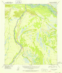
1952 Map of Big Delta A-5
USGS Topo · Published 1952About this map
The Tanana River corridor serves as the primary geographic marker in this 1952 study of interior Alaska, where the northernmost section of the Richardson Highway cuts through the river valley. The landscape is defined by the braided courses of Delta Creek and Clear Creek, flowing through a series of wetlands and topographical variations. This period reflects a time when the infrastructure of the Fourth Judicial Division remained minimal, focused largely around water access and the highway. Grounded evidence of seasonal or remote habitation appears in the form of a lone Cabin and a cluster of Cabins situated near the junction of the terrain's lowlands and rising slopes. Surveyors recorded precision markers at Vabm 1579 Top and Vabm 1579 Low, indicating the importance of these high points for navigating and mapping the surrounding marshy flats and winding waterways.
Find a feature on this map
8 named features on this map. Tap any name to fly to it.
Don’t see what you’re looking for? This feature index may not catch every label — zoom into the map to look around manually.
Map Details
Editions of this 1952 Big Delta A-5 Map
2 editions found

Other maps of this area

1949 · Big Delta B-5
USGS Topo · 1:63,360

1949 · Big Delta B-6
USGS Topo · 1:63,360

1949 · Big Delta A-6
USGS Topo · 1:63,360

1950 · Mount Hayes
USGS Topo · 1:250,000

1950 · Big Delta
USGS Topo · 1:250,000

1950 · Big Delta A-5
USGS Topo · 1:63,360

1950 · Mount Hayes D-4
USGS Topo · 1:63,360

1950 · Big Delta A-4
USGS Topo · 1:63,360

1950 · Mount Hayes D-6
USGS Topo · 1:63,360

1950 · Mount Hayes D-5
USGS Topo · 1:63,360