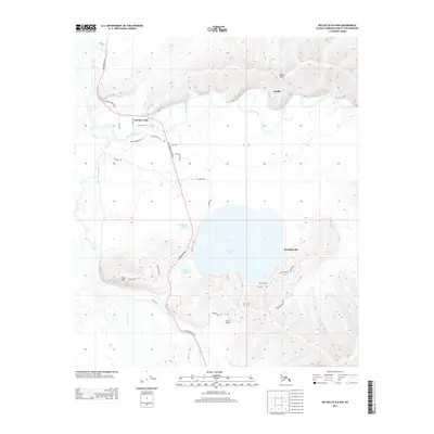
2013 Map of Big Delta B-6 NW
USGS Topo · Published 2013About this map
Harding Lake dominates the center of this landscape, serving as a focal point for the surrounding Salcha community and recreational outposts like Bingle Camp. The terrain is defined by the significant waterway of the Salcha River as it meanders through the northern section, overlooked by the prominent elevation of Salcha Bluff. To the south, the Tanana River cuts through the southwest corner, while smaller bodies of water such as Hartman Lake and Little Lake sit between the larger lake and the highway corridor.
Find a feature on this map
69 named features on this map. Tap any name to fly to it.
Don’t see what you’re looking for? This feature index may not catch every label — zoom into the map to look around manually.
Map Details
Editions of this 2013 Big Delta B-6 NW Map
This is the sole edition of this map. No revisions or reprints were ever made.
Other maps of this area

1949 · Big Delta B-6
USGS Topo · 1:63,360

1949 · Fairbanks C-1
USGS Topo · 1:63,360

1949 · Big Delta C-6
USGS Topo · 1:63,360

1950 · Fairbanks
USGS Topo · 1:250,000

1950 · Big Delta
USGS Topo · 1:250,000

1950 · Fairbanks C-1
USGS Topo · 1:63,360

1950 · Fairbanks B-1
USGS Topo · 1:63,360

1951 · Big Delta
USGS Topo · 1:250,000
1951 · Fairbanks B-1
USGS Topo · 1:63,360

1951 · Fairbanks
USGS Topo · 1:250,000