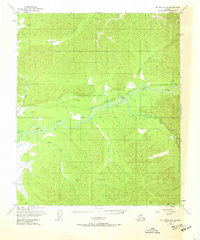
1950 Map of Big Delta D-6
USGS Topo · Published 1965About this map
The Chena River and its meandering tributaries dominate this interior Alaskan landscape, recorded just as post-war mapping efforts began to document the territory's vast drainage systems. The river’s complex path is marked by features like Hodgins Slough and Mullen Slough, while the presence of a Military Reservation in the southern portion of the sheet speaks to the strategic importance of this region in the 1950s. High-altitude photogrammetry captured the intricate hydrology of the South Fork and the remote Winter Trail long before modern development altered the wilderness.
Find a feature on this map
19 named features on this map. Tap any name to fly to it.
Don’t see what you’re looking for? This feature index may not catch every label — zoom into the map to look around manually.
Map Details
Editions of this 1950 Big Delta D-6 Map
2 editions found
Other maps of this area

1945 · Livengood
USGS Topo · 1:250,000

1949 · Fairbanks D-1
USGS Topo · 1:62,500

1949 · Fairbanks C-1
USGS Topo · 1:63,360

1949 · Big Delta C-6
USGS Topo · 1:63,360

1950 · Fairbanks
USGS Topo · 1:250,000

1950 · Big Delta
USGS Topo · 1:250,000

1950 · Big Delta D-6
USGS Topo · 1:63,360

1950 · Fairbanks C-1
USGS Topo · 1:63,360

1951 · Big Delta
USGS Topo · 1:250,000

1951 · Fairbanks
USGS Topo · 1:250,000