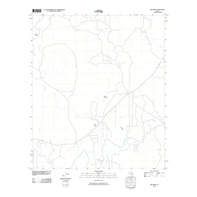
2010 Map of Big Draw
USGS Topo · Published 2010About this map
The Llano River and its numerous tributaries dominate this 2010 Kimble County landscape, illustrating a classic Edwards Plateau drainage pattern. The water network includes the southward-reaching Gentry Creek, Johnson Fork, and the eponymous Big Draw, all converging toward the river's main stem. This modern survey provides a detailed look at the rural property boundaries and roads that crisscross the Texas Hill Country, centered around the distinctive peak of Teacup Mountain. Genealogy researchers will find the Gentry Creek Cemetery situated near the intersection of the creek and the primary highway. Upstream to the northwest, the terrain is defined by the Gorman Draw and the reliably marked Gorman Spring, highlighting the essential role of water sources in this dry, ranching-oriented region of the state.
Find a feature on this map
9 named features on this map. Tap any name to fly to it.
Don’t see what you’re looking for? This feature index may not catch every label — zoom into the map to look around manually.
Map Details
Editions of this 2010 Big Draw Map
This is the sole edition of this map. No revisions or reprints were ever made.
Other maps of this area

1932 · Junction
USGS Topo · 1:62,500

1954 · Llano
USGS Topo · 1:250,000

1955 · Llano
USGS Topo · 1:250,000

1956 · Llano
USGS Topo · 1:250,000

1968 · London
USGS Topo · 1:24,000

1968 · Yates
USGS Topo · 1:24,000

1970 · Julio Draw
USGS Topo · 1:24,000

1970 · Brewer Hollow
USGS Topo · 1:24,000

1970 · Elm Slough
USGS Topo · 1:24,000
1970 · Big Draw
USGS Topo · 1:24,000