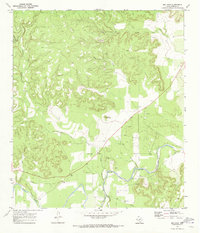
1970 Map of Big Draw
USGS Topo · Published 1973About this map
The Llano River winds through the heart of Kimble County, forming the primary drainage for a landscape defined by deep draws and narrow limestone divides. In the early 1970s, the area remained largely ranchland, evidenced by the numerous Gravel Pits and a prominent Pipeline cutting across the southern terrain. Water sources such as Gorman Spring and the Johnson Fork confluence provided the necessary resources for local landholders in this arid Hill Country region. Local family history is centered around the Gentry Creek Cem, located just north of where Gentry Creek meets the river. Significant landmarks like Teacup Mountain and the wide drainage of Big Draw serve as orienting points for anyone tracing the historic property lines and infrastructure of this rural Texas landscape.
Find a feature on this map
12 named features on this map. Tap any name to fly to it.
Don’t see what you’re looking for? This feature index may not catch every label — zoom into the map to look around manually.
Map Details
Editions of this 1970 Big Draw Map
2 editions found
Other maps of this area

1932 · Junction
USGS Topo · 1:62,500

1954 · Llano
USGS Topo · 1:250,000

1955 · Llano
USGS Topo · 1:250,000

1956 · Llano
USGS Topo · 1:250,000

1968 · London
USGS Topo · 1:24,000

1968 · Yates
USGS Topo · 1:24,000

1970 · Julio Draw
USGS Topo · 1:24,000

1970 · Brewer Hollow
USGS Topo · 1:24,000

1970 · Elm Slough
USGS Topo · 1:24,000
1974 · Junction
USGS Topo · 1:24,000