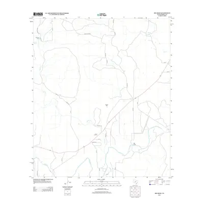
2012 Map of Big Draw
USGS Topo · Published 2012About this map
Llano River and Johnson Fork define the southern hydrology of this Central Texas landscape in the early 21st century. The terrain is characterized by significant topographic features such as Teacup Mtn and the namesake Big Draw, which dominate the central and eastern portions of the quadrangle. For those researching the local heritage of Kimble County, the presence of the Gentry Creek Cem near the intersection of Caldwell Rd and Sullivan Rd provides a specific point of genealogical interest. The mapping reveals a network of county roads, such as Jordan Conger Rd and Gentry Creek Rd, that lace together the drainage basins of Gentry Cr and Red Cr. This area remains largely defined by its water sources, including Gorman Spring and the Gorman Draw in the northwest, illustrating the long-term reliance of regional ranching or settlement on these natural features.
Find a feature on this map
32 named features on this map. Tap any name to fly to it.
Don’t see what you’re looking for? This feature index may not catch every label — zoom into the map to look around manually.
Map Details
Editions of this 2012 Big Draw Map
This is the sole edition of this map. No revisions or reprints were ever made.
Other maps of this area

1932 · Junction
USGS Topo · 1:62,500

1954 · Llano
USGS Topo · 1:250,000

1955 · Llano
USGS Topo · 1:250,000

1956 · Llano
USGS Topo · 1:250,000

1968 · London
USGS Topo · 1:24,000

1968 · Yates
USGS Topo · 1:24,000

1970 · Julio Draw
USGS Topo · 1:24,000

1970 · Brewer Hollow
USGS Topo · 1:24,000

1970 · Elm Slough
USGS Topo · 1:24,000
1970 · Big Draw
USGS Topo · 1:24,000