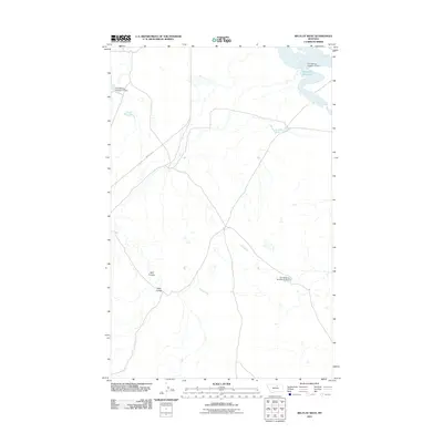
2011 Map of Big Flat West
USGS Topo · Published 2011About this map
Indian Hwy 8 cuts across this northern Montana landscape, revealing a region defined by critical water management systems and natural drainage patterns. The northern reaches are dominated by the Weigand Reservoir, a significant water body supported by infrastructure such as the Fort Belknap Number 14 Dam. These engineered structures, including Fort Belknap Number 12 Dam and Fort Belknap Number 16 Dam to the south, highlight the importance of irrigation and water storage in the Lodge Pole District's arid environment. The terrain is further characterized by the deep incisions of Wolf Coulee and Allen Coulee, which serve as primary geographic landmarks in this sparse, open territory. The lack of dense settlement names suggests a focused agricultural or reservation-based land use where water control is the primary driver of development.
Find a feature on this map
7 named features on this map. Tap any name to fly to it.
Don’t see what you’re looking for? This feature index may not catch every label — zoom into the map to look around manually.
Map Details
Editions of this 2011 Big Flat West Map
This is the sole edition of this map. No revisions or reprints were ever made.
Other maps of this area

1953 · Havre
USGS Topo · 1:250,000

1957 · Havre
USGS Topo · 1:250,000

1958 · Havre
USGS Topo · 1:250,000

1964 · Coburg SE
USGS Topo · 1:24,000

1964 · Weigand Reservoir
USGS Topo · 1:24,000

1971 · Big Flat East
USGS Topo · 1:24,000

1971 · Lodge Pole NE
USGS Topo · 1:24,000
1971 · Lodge Pole
USGS Topo · 1:24,000
1971 · Bigby Lake
USGS Topo · 1:24,000
1971 · Ball Coulee
USGS Topo · 1:24,000