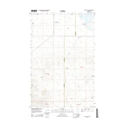
2014 Map of Big Flat West
USGS Topo · Published 2014About this map
Big Flat characterizes the high, open terrain of this region along the border of Blaine and Phillips Counties. The landscape is defined by a series of significant drainage features, including Corral Coulee and Lone Tree Coulee to the north, which give way to the deeper incisions of Wolf Coulee and Chicken Coulee further south. These landforms trace the natural flow of water across the prairie toward the more substantial Rocky Coulee in the southeast corner. Human presence is marked by the long stretch of Mud Creek Rd and Bia-8, which provide the primary access through this rural expanse. In the northeast, Weigand Reservoir serves as a critical water resource for this arid environment, illustrating the engineering required to support land use in this part of the state.
Find a feature on this map
16 named features on this map. Tap any name to fly to it.
Don’t see what you’re looking for? This feature index may not catch every label — zoom into the map to look around manually.
Map Details
Editions of this 2014 Big Flat West Map
This is the sole edition of this map. No revisions or reprints were ever made.
Other maps of this area

1953 · Havre
USGS Topo · 1:250,000

1957 · Havre
USGS Topo · 1:250,000

1958 · Havre
USGS Topo · 1:250,000

1964 · Coburg SE
USGS Topo · 1:24,000

1964 · Weigand Reservoir
USGS Topo · 1:24,000

1971 · Big Flat East
USGS Topo · 1:24,000

1971 · Lodge Pole NE
USGS Topo · 1:24,000
1971 · Lodge Pole
USGS Topo · 1:24,000
1971 · Bigby Lake
USGS Topo · 1:24,000
1971 · Ball Coulee
USGS Topo · 1:24,000