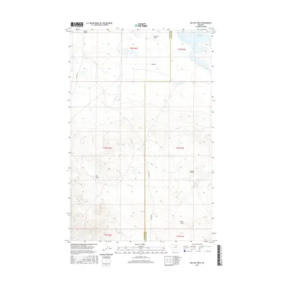
2017 Map of Big Flat West
USGS Topo · Published 2017About this map
Big Flat dominates this high-plains landscape, where the plateau is deeply incised by a network of drainage features. These intermittent watercourses, including Corral Coulee and Lone Tree Coulee, characterize the northern reaches of the quadrangle. To the northeast, the Weigand Reservoir provides a primary point of water collection in an otherwise arid environment. This 2017 survey reflects a sparsely populated region of Montana, defined by the administrative boundary between Blaine Co and Phillips Co. Infrastructure is limited to essential connectors like Indian Hwy 8 and Mud Creek Rd, which navigate the elevation changes between the flat tops and the coulee floors. Named landmarks such as Wolf Coulee and Chicken Coulee provide critical navigation points for those working the rangelands of the t28n r25e and t28n r26e township grids.
Find a feature on this map
16 named features on this map. Tap any name to fly to it.
Don’t see what you’re looking for? This feature index may not catch every label — zoom into the map to look around manually.
Map Details
Editions of this 2017 Big Flat West Map
This is the sole edition of this map. No revisions or reprints were ever made.
Other maps of this area

1953 · Havre
USGS Topo · 1:250,000

1957 · Havre
USGS Topo · 1:250,000

1958 · Havre
USGS Topo · 1:250,000

1964 · Coburg SE
USGS Topo · 1:24,000

1964 · Weigand Reservoir
USGS Topo · 1:24,000

1971 · Big Flat East
USGS Topo · 1:24,000

1971 · Lodge Pole NE
USGS Topo · 1:24,000
1971 · Lodge Pole
USGS Topo · 1:24,000
1971 · Bigby Lake
USGS Topo · 1:24,000
1971 · Ball Coulee
USGS Topo · 1:24,000