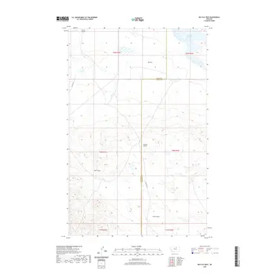
2020 Map of Big Flat West
USGS Topo · Published 2020About this map
Big Flat characterizes this section of north-central Montana, where the plateau landscape is etched by a series of drainage coulees. The boundary between Blaine Co and Phillips Co runs vertically through the center of the sheet, providing a precise reference for local land records and historical property boundaries. The northern reaches are marked by Weigand Reservoir, while the southern terrain transitions into the complex topography of Rocky Coulee and Wolf Coulee. Transportation across this open country is defined by the corridor of Indian Hwy 8 in the west and Mud Creek Rd near the county line. The map illustrates a landscape of high plains punctuated by seasonal watercourses like Chicken Coulee and Corral Coulee, reflecting the ranching and agricultural patterns of the region near the turn of the 21st century.
Find a feature on this map
15 named features on this map. Tap any name to fly to it.
Don’t see what you’re looking for? This feature index may not catch every label — zoom into the map to look around manually.
Map Details
Editions of this 2020 Big Flat West Map
This is the sole edition of this map. No revisions or reprints were ever made.
Other maps of this area

1953 · Havre
USGS Topo · 1:250,000

1957 · Havre
USGS Topo · 1:250,000

1958 · Havre
USGS Topo · 1:250,000

1964 · Coburg SE
USGS Topo · 1:24,000

1964 · Weigand Reservoir
USGS Topo · 1:24,000

1971 · Big Flat East
USGS Topo · 1:24,000

1971 · Lodge Pole NE
USGS Topo · 1:24,000
1971 · Lodge Pole
USGS Topo · 1:24,000
1971 · Bigby Lake
USGS Topo · 1:24,000
1971 · Ball Coulee
USGS Topo · 1:24,000