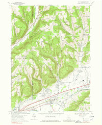
1969 Map of Big Flats
USGS Topo · Published 1979About this map
Big Flats occupies the broad valley where Winfield Creek meets the Chemung River, serving as a vital transport corridor during the late 1960s. The landscape is defined by its industrial and transit infrastructure, featuring both the Penn Central and Erie-Lackawanna railroads alongside the Chemung County Airport. This era of development is juxtaposed against a deeply rooted rural history, evidenced by numerous family-named hollows like Breed Hollow and Eacher Hollow that cut through the surrounding uplands.
Find a feature on this map
58 named features on this map. Tap any name to fly to it.
Don’t see what you’re looking for? This feature index may not catch every label — zoom into the map to look around manually.
Map Details
Editions of this 1969 Big Flats Map
Other maps of this area

1895 · Elmira
USGS Topo · 1:62,500

1898 · Watkins Glen
USGS Topo · 1:62,500

1901 · Watkins
USGS Topo · 1:62,500

1903 · Hammondsport
USGS Topo · 1:62,500

1905 · Watkins Glen
USGS Topo · 1:125,000

1914 · Corning
USGS Topo · 1:62,500

1944 · Corning
USGS Topo · 1:62,500

1950 · Elmira
USGS Topo · 1:250,000

1950 · Montour Falls
USGS Topo · 1:24,000

1953 · Bradford
USGS Topo · 1:24,000