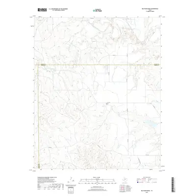
2019 Map of Big Four Ranch
USGS Topo · Published 2019About this map
The Middle Fork Wichita River and North Wichita River carve through this section of the Rolling Plains where the borders of Foard, Knox, and King counties meet. This ranching landscape is defined by its drainage systems, including Good Cr and Buffalo Cr, which flow toward the larger Wichita River branches. The eponymous Big Four Ranch serves as a central landmark in an area otherwise characterized by extensive rangeland and a network of county roads. The terrain shows the transition from the high plains into the breaks of the Wichita River, with cattle ranching operations evidenced by the naming of Alexander Ranch Rd and other rural infrastructure. This 2019 survey documents the enduring pastoral character of North Texas, where large landholdings continue to shape the local geography and economy.
Find a feature on this map
20 named features on this map. Tap any name to fly to it.
Don’t see what you’re looking for? This feature index may not catch every label — zoom into the map to look around manually.
Map Details
Editions of this 2019 Big Four Ranch Map
This is the sole edition of this map. No revisions or reprints were ever made.
Other maps of this area

1954 · Lubbock
USGS Topo · 1:250,000

1954 · Wichita Falls
USGS Topo · 1:250,000

1958 · Wichita Falls
USGS Topo · 1:250,000

1966 · Truscott North
USGS Topo · 1:24,000

1966 · Truscott South
USGS Topo · 1:24,000

1966 · Ox Yoke Creek
USGS Topo · 1:24,000

1966 · Big Four Ranch
USGS Topo · 1:24,000

1966 · Maverick Flat
USGS Topo · 1:24,000

1966 · Lowrance Mountain
USGS Topo · 1:24,000

1968 · Y Ranch
USGS Topo · 1:24,000