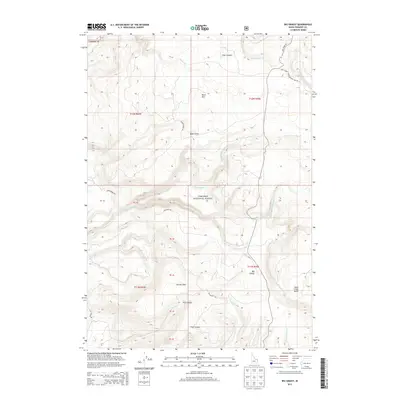
2013 Map of Big Grassy
USGS Topo · Published 2013About this map
Targhee National Forest defines this high-elevation landscape in eastern Idaho, where the complex drainage systems of the Targhee NF meet the peaks of the Centennial Mountains. The terrain is marked by significant landforms including Big Grassy and Snow Creek Butte in the southeast, while Black Mtn dominates the northern sector. A network of canyons and draws, such as Trail Canyon, Baker Draw, and Survey Draw, illustrates the erosive power of mountain streams like S Fork Split Cr and N Fork Partridge Cr. Access through this wilderness area is restricted to a few specialized routes, including Fish Creek Rd and the Natl Forest Develop Road 108 Rd. These roads and trails follow the natural contours of the land, providing a view of the remote backcountry and the industrial footprint of the Long Haul Rd.
Find a feature on this map
33 named features on this map. Tap any name to fly to it.
Don’t see what you’re looking for? This feature index may not catch every label — zoom into the map to look around manually.
Map Details
Editions of this 2013 Big Grassy Map
This is the sole edition of this map. No revisions or reprints were ever made.
Other maps of this area

1955 · Ashton
USGS Topo · 1:250,000

1957 · Warm River Butte
USGS Topo · 1:62,500

1957 · Buffalo Lake
USGS Topo · 1:62,500

1958 · Ashton
USGS Topo · 1:250,000

1960 · Ashton
USGS Topo · 1:250,000

1964 · Hatchery Butte
USGS Topo · 1:24,000

1964 · Island Park
USGS Topo · 1:24,000

1965 · Snake River Butte
USGS Topo · 1:24,000
1986 · Latham Spring
USGS Topo · 1:24,000
1986 · Buffalo Lake NE
USGS Topo · 1:24,000