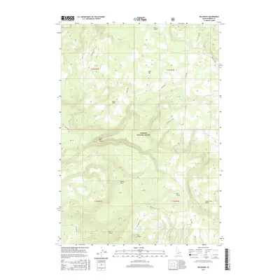
2017 Map of Big Grassy
USGS Topo · Published 2017About this map
Targhee National Forest encompasses this high-elevation landscape in eastern Idaho, where the geological footprint of the Island Park Caldera transitions into a network of ridges and canyons. The terrain is defined by prominent elevations such as Black Mtn and Snow Creek Butte, overlooking a series of drainage basins including Survey Draw and Flat Canyon. A complex hydrologic system feeds the region, with the S Fork Split Creek and Partridge Creek systems carving through the timbered terrain. The presence of numerous designated survey blocks, labeled PB 39 through PB 50, indicates the structured management of these public lands. This 2017 survey shows the intricate system of forest access routes like Big Grassy Spur 2 and Fish Creek Spur 20A that facilitate movement through the dense forest and across the high plateaus of Big Grassy.
Find a feature on this map
32 named features on this map. Tap any name to fly to it.
Don’t see what you’re looking for? This feature index may not catch every label — zoom into the map to look around manually.
Map Details
Editions of this 2017 Big Grassy Map
This is the sole edition of this map. No revisions or reprints were ever made.
Other maps of this area

1955 · Ashton
USGS Topo · 1:250,000

1957 · Warm River Butte
USGS Topo · 1:62,500

1957 · Buffalo Lake
USGS Topo · 1:62,500

1958 · Ashton
USGS Topo · 1:250,000

1960 · Ashton
USGS Topo · 1:250,000

1964 · Hatchery Butte
USGS Topo · 1:24,000

1964 · Island Park
USGS Topo · 1:24,000

1965 · Snake River Butte
USGS Topo · 1:24,000
1986 · Latham Spring
USGS Topo · 1:24,000
1986 · Buffalo Lake NE
USGS Topo · 1:24,000