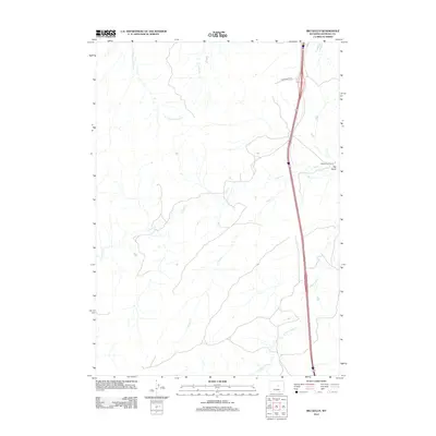
2012 Map of Big Gulch
USGS Topo · Published 2012About this map
Shepperson Ranch and the small settlement of Big Gulch define the inhabited landscape of this Natrona County interior in the early twenty-first century. The terrain is structured by an intricate drainage system including N Fork Dead Horse Cr, Dugout Cr, and the sprawling reaches of Castle Cr. These seasonal watercourses dictate the placement of ranching infrastructure and local transit, most notably Shepperson Rd, which serves the central ranching interests.
Find a feature on this map
8 named features on this map. Tap any name to fly to it.
Don’t see what you’re looking for? This feature index may not catch every label — zoom into the map to look around manually.
Map Details
Editions of this 2012 Big Gulch Map
This is the sole edition of this map. No revisions or reprints were ever made.
Other maps of this area

1955 · Arminto
USGS Topo · 1:250,000

1958 · Arminto
USGS Topo · 1:250,000

1962 · Arminto
USGS Topo · 1:250,000

1968 · Big Gulch
USGS Topo · 1:24,000

1968 · Merino
USGS Topo · 1:24,000

1968 · Midwest
USGS Topo · 1:24,000

1968 · Salt Creek
USGS Topo · 1:24,000
1968 · Statzer Point
USGS Topo · 1:24,000
1968 · Teapot Rock
USGS Topo · 1:24,000

1968 · Camel Hump Reservoir
USGS Topo · 1:24,000