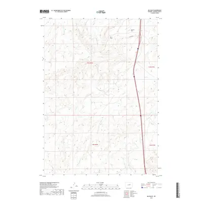
2017 Map of Big Gulch
USGS Topo · Published 2017About this map
Big Gulch defines the drainage patterns of this corner of Natrona County, where the high plains of central Wyoming are carved by a network of seasonal watercourses. The landscape is structured by the prominent Bothwell Draw and the various branches of the Castle Cr system, including the S Fork Castle Cr. These drainages, along with Alkali Cr and Dugout Cr, illustrate the intricate topographic relief of the region's rangeland. Human presence is sparse, anchored primarily by Shepperson Rd which provides access through the northern reaches of the quadrangle. The map captures a moment in the modern era where traditional township and range divisions, such as t39n r80w and t38n r79w, remain the primary landmarks across the expansive terrain.
Find a feature on this map
12 named features on this map. Tap any name to fly to it.
Don’t see what you’re looking for? This feature index may not catch every label — zoom into the map to look around manually.
Map Details
Editions of this 2017 Big Gulch Map
This is the sole edition of this map. No revisions or reprints were ever made.
Other maps of this area

1955 · Arminto
USGS Topo · 1:250,000

1958 · Arminto
USGS Topo · 1:250,000

1962 · Arminto
USGS Topo · 1:250,000

1968 · Big Gulch
USGS Topo · 1:24,000

1968 · Merino
USGS Topo · 1:24,000

1968 · Midwest
USGS Topo · 1:24,000

1968 · Salt Creek
USGS Topo · 1:24,000
1968 · Statzer Point
USGS Topo · 1:24,000
1968 · Teapot Rock
USGS Topo · 1:24,000

1968 · Camel Hump Reservoir
USGS Topo · 1:24,000