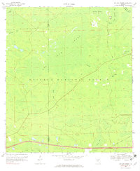
1969 Map of Big Gum Swamp
USGS Topo · Published 1971About this map
Big Gum Swamp dominates this landscape on the border of Baker and Columbia Counties, forming a dense hydrologic network within the Osceola National Forest. The 1969 survey captures a period of forest management and early interstate-era development, showing the transition from the wild wetlands of Impassable Bay and Williams Bay to the commercial thoroughfares at the southern edge. The presence of Seventeenmile Camp and the established route of Seventeenmile Road indicate the historic importance of logging and access through these reaches.
Find a feature on this map
18 named features on this map. Tap any name to fly to it.
Don’t see what you’re looking for? This feature index may not catch every label — zoom into the map to look around manually.
Map Details
Editions of this 1969 Big Gum Swamp Map
3 editions found
Other maps of this area

1954 · Valdosta
USGS Topo · 1:250,000

1958 · Valdosta
USGS Topo · 1:250,000

1959 · Valdosta
USGS Topo · 1:250,000

1961 · Deep Creek
USGS Topo · 1:24,000

1962 · Lake City East
USGS Topo · 1:24,000

1963 · Olustee
USGS Topo · 1:24,000

1963 · Sanderson South
USGS Topo · 1:24,000

1969 · Sanderson NW
USGS Topo · 1:24,000

1969 · Sanderson North
USGS Topo · 1:24,000
1969 · Fairview
USGS Topo · 1:24,000