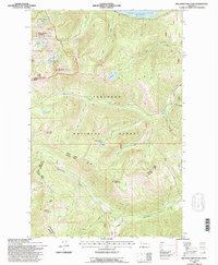
1994 Map of Big Hawk Mountain
USGS Topo · Published 1996About this map
Jewel Basin Hiking Area and the high peaks of the northern Swan Range dominate this 1990s wilderness survey, where dramatic alpine terrain meets the southern reaches of the Hungry Horse Reservoir. The map documents a high-elevation landscape defined by glacial cirques and named summits, including Three Eagles Mountain, Big Hawk Mountain, and Mount Orvis Evans. A network of creeks, such as Wheeler Creek and Quintonkon Creek, drains the steep slopes of the Flathead National Forest, feeding into the reservoir at Graves Bay. This edition reflects a period of established forest management and recreational access, shown through the system of Forest Service roads like the Hungry Spotted Bear Rd and the Swan Hungry Horse Rd that navigate the ridges and valleys between Lake and Flathead counties.
Find a feature on this map
31 named features on this map. Tap any name to fly to it.
Don’t see what you’re looking for? This feature index may not catch every label — zoom into the map to look around manually.
Map Details
Editions of this 1994 Big Hawk Mountain Map
This is the sole edition of this map. No revisions or reprints were ever made.
Other maps of this area

1914 · Nyack
USGS Topo · 1:125,000

1955 · Choteau
USGS Topo · 1:250,000

1957 · Choteau
USGS Topo · 1:250,000

1958 · Choteau
USGS Topo · 1:250,000

1958 · Quintonkon
USGS Topo · 1:24,000

1958 · Felix Peak
USGS Topo · 1:24,000

1960 · Cut Bank
USGS Topo · 1:250,000

1962 · Choteau
USGS Topo · 1:250,000

1963 · Cut Bank
USGS Topo · 1:250,000

1964 · Cut Bank
USGS Topo · 1:250,000