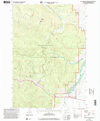
1997 Map of Big Hole Battlefield
USGS Topo · Published 2002About this map
Big Hole National Battlefield preserves the site of a pivotal 1877 conflict, marked here in detail within the Beaverhead National Forest. The landscape is dominated by the steep slopes of Battle Mountain and Wooster Mountain, where the geography of the Nez Perce retreat and the subsequent military engagement is traceable through specific landmarks like the Howitzer Pit. Along the lower elevations, Lewis and Clark National Historic Trail follows the path of the river, passing the legacy of later resource extraction at Dredge Tailings and Borrow Pits.
Find a feature on this map
25 named features on this map. Tap any name to fly to it.
Don’t see what you’re looking for? This feature index may not catch every label — zoom into the map to look around manually.
Map Details
Editions of this 1997 Big Hole Battlefield Map
This is the sole edition of this map. No revisions or reprints were ever made.
Other maps of this area

1955 · Dillon
USGS Topo · 1:250,000

1957 · Dillon
USGS Topo · 1:250,000

1958 · Dillon
USGS Topo · 1:250,000

1962 · Dillon
USGS Topo · 1:250,000

1965 · Dillon
USGS Topo · 1:250,000

1966 · Gibbons School
USGS Topo · 1:24,000

1966 · Big Hole Battlefield
USGS Topo · 1:24,000

1966 · Big Hole Pass
USGS Topo · 1:24,000
1966 · Elk Creek
USGS Topo · 1:24,000
1966 · Highland Ranch
USGS Topo · 1:24,000