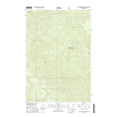
2017 Map of Big Huckleberry Mountain
USGS Topo · Published 2017About this map
The Gifford Pinchot National Forest defines the character of this 2017 survey, where dense river drainages and high peaks dominate the southern Washington landscape. The Wind River and Little Wind River converge in the southwest corner, while the Pacific Crest National Scenic Trail traverses the northeastern ridges near Big Huckleberry Mtn. This modern record illustrates the extensive network of forest management roads, such as Nat For Dev Rd 65 and Cedar Creek Rd, that provide access to the timberlands and high-altitude landmarks. Surveyed points like Weigle Hill and Gobblers Knob rise between the deep cuts of Panther Cr and Bear Cr, showing the complex drainage patterns that feed into the Columbia River system further south. The inclusion of Old State Rd and Old Detour Rd offers a trace of earlier transportation routes through this managed wilderness.
Find a feature on this map
32 named features on this map. Tap any name to fly to it.
Don’t see what you’re looking for? This feature index may not catch every label — zoom into the map to look around manually.
Map Details
Editions of this 2017 Big Huckleberry Mountain Map
This is the sole edition of this map. No revisions or reprints were ever made.
Other maps of this area

1926 · Hood River
USGS Topo · 1:125,000

1929 · Hood River
USGS Topo · 1:125,000

1953 · The Dalles
USGS Topo · 1:250,000

1956 · The Dalles
USGS Topo · 1:250,000

1957 · The Dalles
USGS Topo · 1:250,000

1957 · Bonneville Dam
USGS Topo · 1:62,500

1957 · Wind River
USGS Topo · 1:62,500

1957 · Willard
USGS Topo · 1:62,500

1957 · Hood River
USGS Topo · 1:62,500
1979 · Bonneville Dam
USGS Topo · 1:24,000