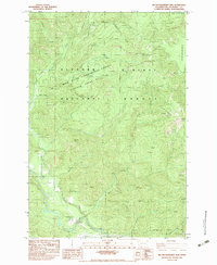
1983 Map of Big Huckleberry Mtn
USGS Topo · Published 1983About this map
The Gifford Pinchot National Forest covers this landscape in the early 1980s, defined by the drainage systems of the Little Wind River and numerous mountain creeks. Central to the map is the Wind River Experimental Forest Division, a dedicated research area that spans several ridges including Panther Creek and Cedar Creek. The terrain is marked by prominent high points such as Big Huckleberry Mtn, Gobblers Knob, and Weigle Hill, while the eastern margin reveals the distinct geological feature of the Big Lava Bed. In the southwest, a Suspension Bridge crosses the river near a forest boundary, indicating the specific infrastructure used for access and resource management. This survey provides a record of land use through the presence of a Gravel Pit and Borrow Pit, alongside natural water sources like Cold Spring.
Find a feature on this map
24 named features on this map. Tap any name to fly to it.
Don’t see what you’re looking for? This feature index may not catch every label — zoom into the map to look around manually.
Map Details
Editions of this 1983 Big Huckleberry Mtn Map
This is the sole edition of this map. No revisions or reprints were ever made.
Other maps of this area

1926 · Hood River
USGS Topo · 1:125,000

1929 · Hood River
USGS Topo · 1:125,000

1953 · The Dalles
USGS Topo · 1:250,000

1956 · The Dalles
USGS Topo · 1:250,000

1957 · The Dalles
USGS Topo · 1:250,000

1957 · Bonneville Dam
USGS Topo · 1:62,500

1957 · Wind River
USGS Topo · 1:62,500

1957 · Willard
USGS Topo · 1:62,500

1957 · Hood River
USGS Topo · 1:62,500
1979 · Bonneville Dam
USGS Topo · 1:24,000