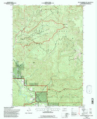
1994 Map of Big Huckleberry Mtn
USGS Topo · Published 1997About this map
The Gifford Pinchot National Forest dominates this landscape, showing a complex network of forest management and natural features in the mid-1990s. The map highlights the Wind River Experimental Forest Division, a specialized research area dedicated to silviculture and ecology. Along the southern edge, the terrain transitions into the Columbia River Gorge National Scenic Area, where the Wind River and Little Wind River converge near a Suspension Bridge.
Find a feature on this map
38 named features on this map. Tap any name to fly to it.
Don’t see what you’re looking for? This feature index may not catch every label — zoom into the map to look around manually.
Map Details
Editions of this 1994 Big Huckleberry Mtn Map
This is the sole edition of this map. No revisions or reprints were ever made.
Other maps of this area

1926 · Hood River
USGS Topo · 1:125,000

1929 · Hood River
USGS Topo · 1:125,000

1953 · The Dalles
USGS Topo · 1:250,000

1956 · The Dalles
USGS Topo · 1:250,000

1957 · The Dalles
USGS Topo · 1:250,000

1957 · Bonneville Dam
USGS Topo · 1:62,500

1957 · Wind River
USGS Topo · 1:62,500

1957 · Willard
USGS Topo · 1:62,500

1957 · Hood River
USGS Topo · 1:62,500
1979 · Bonneville Dam
USGS Topo · 1:24,000