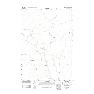
2011 Map of Big Ice Cave
USGS Topo · Published 2011About this map
Big Pryor Mountain anchors this rugged Carbon County landscape, where deep drainages and high plateaus dictate the pattern of human settlement. In this high-country environment, the legacy of ranching is visible through the presence of the Greenough Ranch and Schwend Ranch, located along the upper reaches of the North Fork Sage Creek. The geography is defined by a network of seasonal and perennial water sources, including the strategically located Teeples Spring and Tony Island Spring, which likely served as vital stopovers for livestock and local travel. Landforms such as Harsten Flat and Tie Flat offer rare stretches of level ground amidst a complex system of ridges and hollows, including Commissary Ridge and the aptly named Mill Hollow. The map also captures the headwaters of Pryor Creek and East Pryor Creek, illustrating how these waterways carve through the limestone terrain of southern Montana.
Find a feature on this map
27 named features on this map. Tap any name to fly to it.
Don’t see what you’re looking for? This feature index may not catch every label — zoom into the map to look around manually.
Map Details
Editions of this 2011 Big Ice Cave Map
This is the sole edition of this map. No revisions or reprints were ever made.
Other maps of this area

1954 · Billings
USGS Topo · 1:250,000

1957 · Billings
USGS Topo · 1:250,000

1958 · Billings
USGS Topo · 1:250,000

1964 · Big Ice Cave
USGS Topo · 1:24,000

1964 · Red Pryor Mountain
USGS Topo · 1:24,000

1964 · East Pryor Mountain
USGS Topo · 1:24,000
1964 · Mystery Cave
USGS Topo · 1:24,000

1967 · Deep Creek SE
USGS Topo · 1:24,000

1967 · Castle Rocks
USGS Topo · 1:24,000

1967 · Deep Creek SW
USGS Topo · 1:24,000