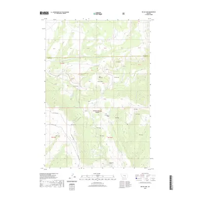
2020 Map of Big Ice Cave
USGS Topo · Published 2020About this map
Custer National Forest encompasses this high-elevation landscape within the Pryor Mountains, where the namesake Big Ice Cave serves as a prominent geologic landmark. The terrain is defined by a series of steep drainages and flat-topped landforms, such as Roberts Bench and Harsten Flat, which overlook deep basins like Tibbs Hollow and Mill Hollow. This 2020 survey illustrates a remote wilderness utilized for its natural water sources, including Roberts Spring and Trappers Cabin Spring.
Find a feature on this map
39 named features on this map. Tap any name to fly to it.
Don’t see what you’re looking for? This feature index may not catch every label — zoom into the map to look around manually.
Map Details
Editions of this 2020 Big Ice Cave Map
This is the sole edition of this map. No revisions or reprints were ever made.
Other maps of this area

1954 · Billings
USGS Topo · 1:250,000

1957 · Billings
USGS Topo · 1:250,000

1958 · Billings
USGS Topo · 1:250,000

1964 · Big Ice Cave
USGS Topo · 1:24,000

1964 · Red Pryor Mountain
USGS Topo · 1:24,000

1964 · East Pryor Mountain
USGS Topo · 1:24,000
1964 · Mystery Cave
USGS Topo · 1:24,000

1967 · Deep Creek SE
USGS Topo · 1:24,000

1967 · Castle Rocks
USGS Topo · 1:24,000

1967 · Deep Creek SW
USGS Topo · 1:24,000