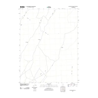
2010 Map of Big Jensen Pass
USGS Topo · Published 2010About this map
Big Jensen Pass and Little Jensen Pass serve as the primary navigational corridors through the Burbank Hills in this high-desert portion of Millard County. The map details a network of dry drainages such as Jensen Wash and Deadman Wash that define the local topography, alongside the remote reach of Antelope Valley. Travel in this era relied on established routes like Deadman Rd and Cowboy Rd, which navigate the gaps between the hills and the Tunnel Spring Mountains to the east. The presence of Tunnel Spring suggests a critical water source in an otherwise arid landscape dominated by sage and juniper. This survey captures the sparse infrastructure of the Great Basin, where land use is dictated by the rugged gaps of Juniper Pass and Cowboy Pass.
Find a feature on this map
12 named features on this map. Tap any name to fly to it.
Don’t see what you’re looking for? This feature index may not catch every label — zoom into the map to look around manually.
Map Details
Editions of this 2010 Big Jensen Pass Map
This is the sole edition of this map. No revisions or reprints were ever made.
Other maps of this area

1953 · Richfield
USGS Topo · 1:250,000

1958 · Richfield
USGS Topo · 1:250,000

1960 · Burbank Hills
USGS Topo · 1:62,500

1960 · Wah Wah Summit
USGS Topo · 1:62,500

1960 · Crystal Peak
USGS Topo · 1:62,500

1971 · Tunnel Spring
USGS Topo · 1:24,000

1971 · Mormon Gap
USGS Topo · 1:24,000

1980 · Wah Wah Mts. North
USGS Topo · 1:100,000
1989 · Pine Valley Hardpan North
USGS Topo · 1:24,000
1991 · Middle Mountain
USGS Topo · 1:24,000