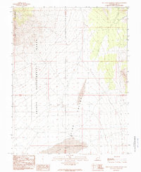
1989 Map of Pine Valley Hardpan North
USGS Topo · Published 1989About this map
The Desert Experimental Range occupies the central and western expanse of this high-desert basin, illustrating federal land management and ecological study in the late twentieth century. This arid landscape is dominated by the vast Pine Valley Hardpan and the broader Pine Valley, where water is a scarce and vital resource. The presence of Guyman Well provides a rare point of human infrastructure in an otherwise remote terrain, while the Tunnel Spring Mountains rise to the northwest to define the basin's edge. Transportation is limited to rugged tracks and the Sand Pass Road, reflecting the area's isolation and its primary use for scientific observation and open-range livestock management. The map details the Township and Range boundaries, such as T 24 S and T 25 S, which organize this sparsely populated portion of Millard County.
Find a feature on this map
9 named features on this map. Tap any name to fly to it.
Don’t see what you’re looking for? This feature index may not catch every label — zoom into the map to look around manually.
Map Details
Editions of this 1989 Pine Valley Hardpan North Map
This is the sole edition of this map. No revisions or reprints were ever made.
Other maps of this area

1953 · Richfield
USGS Topo · 1:250,000

1958 · Richfield
USGS Topo · 1:250,000

1960 · Burbank Hills
USGS Topo · 1:62,500

1960 · Wah Wah Summit
USGS Topo · 1:62,500

1960 · Crystal Peak
USGS Topo · 1:62,500

1971 · Halfway Summit
USGS Topo · 1:24,000

1971 · Tunnel Spring
USGS Topo · 1:24,000

1980 · Wah Wah Mts. North
USGS Topo · 1:100,000
1989 · Wah Wah Summit
USGS Topo · 1:24,000
1989 · Pine Valley Hardpan South
USGS Topo · 1:24,000