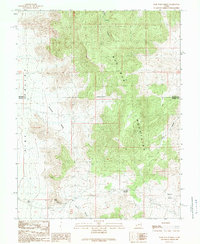
1989 Map of Wah Wah Summit
USGS Topo · Published 1989About this map
Wah Wah Mountains dominate the central topography of this 1989 survey, separating the high desert flats of the Pine Valley Depression from the interior valleys. This provisional map, compiled from aerial photography dating back to 1953, reveals a landscape defined by its aridity and isolation, where human presence is marked by sparse settlements such as Kelleys Place and a nameless Ranch. The terrain is deeply incised by drainages like Corral Canyon and Lawson Cove, while the presence of a Drill Hole and several labels for Prospect or Prospects indicate small-scale mineral exploration typical of the Great Basin during this era. Traversing the heights of Wah Wah Summit, the map captures the transition between Beaver and Millard counties along an indefinite boundary, providing a clear record of the livestock and mining infrastructure that once supported this remote corridor.
Find a feature on this map
17 named features on this map. Tap any name to fly to it.
Don’t see what you’re looking for? This feature index may not catch every label — zoom into the map to look around manually.
Map Details
Editions of this 1989 Wah Wah Summit Map
This is the sole edition of this map. No revisions or reprints were ever made.
Other maps of this area

1953 · Richfield
USGS Topo · 1:250,000

1958 · Richfield
USGS Topo · 1:250,000

1959 · Frisco
USGS Topo · 1:62,500

1960 · Frisco Peak
USGS Topo · 1:62,500

1960 · Wah Wah Summit
USGS Topo · 1:62,500

1971 · Sewing Machine Pass
USGS Topo · 1:24,000

1971 · Lamerdorf Peak NW
USGS Topo · 1:24,000

1980 · Wah Wah Mts. South
USGS Topo · 1:100,000

1980 · Wah Wah Mts. North
USGS Topo · 1:100,000
1989 · Wah Wah Cove
USGS Topo · 1:24,000