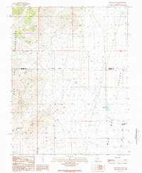
1989 Map of Wah Wah Cove
USGS Topo · Published 1989About this map
Kelleys Place and Wild Horse Corral sit at the margins of a high desert landscape defined by the transition from the Wah Wah Mountains down into the Wah Wah Valley. The map, reflecting fieldwork through 1986, documents a network of arid-land water management, including Dutchman Reservoir, Newhouse Reservoir, and several Water Tank sites strategically placed near the Wah Wah Wash. The presence of Prospects in the northern slopes suggests the area's history of mineral exploration. Crossing the center of the sheet is the Millard Co Beaver Co boundary, which divides the terrain between Wah Wah Cove and the northern reaches of Long Valley. This provisional survey is essential for understanding the livestock and water infrastructure of the Great Basin during the late twentieth century.
Find a feature on this map
12 named features on this map. Tap any name to fly to it.
Don’t see what you’re looking for? This feature index may not catch every label — zoom into the map to look around manually.
Map Details
Editions of this 1989 Wah Wah Cove Map
This is the sole edition of this map. No revisions or reprints were ever made.
Other maps of this area

1953 · Richfield
USGS Topo · 1:250,000

1958 · Richfield
USGS Topo · 1:250,000

1959 · Frisco
USGS Topo · 1:62,500

1960 · Frisco Peak
USGS Topo · 1:62,500

1960 · Wah Wah Summit
USGS Topo · 1:62,500

1971 · Sewing Machine Pass
USGS Topo · 1:24,000

1980 · Wah Wah Mts. South
USGS Topo · 1:100,000

1980 · Wah Wah Mts. North
USGS Topo · 1:100,000
1989 · Frisco Peak
USGS Topo · 1:24,000
1989 · Wah Wah Summit
USGS Topo · 1:24,000