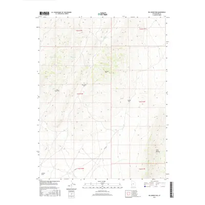
2017 Map of Big Jensen Pass
USGS Topo · Published 2017About this map
Burbank Hills dominate this portion of Millard County, creating a rugged divide between major basins. This 2017 topographical survey captures the complex drainage systems of the area, including Deadman Wash to the north and the diverging paths of North Juniper Wash and South Juniper Wash. High elevation travel through this terrain is defined by several natural gateways, most notably Big Jensen Pass and Little Jensen Pass, which provide passage through the central ridgelines. To the east, the Cowboy Pass sits near the edge of the Tunnel Spring Mountains, while the lower elevations of Antelope Valley begin to open up in the southwest corner. The only named vehicular thoroughfare, Cowboy Rd, cuts across the southeastern township boundaries, serving as a vital link through this desert landscape. The map's detailed contour lines illustrate the stark relief and the network of ephemeral washes like Jensen Wash that define the local hydrology.
Find a feature on this map
17 named features on this map. Tap any name to fly to it.
Don’t see what you’re looking for? This feature index may not catch every label — zoom into the map to look around manually.
Map Details
Editions of this 2017 Big Jensen Pass Map
This is the sole edition of this map. No revisions or reprints were ever made.
Other maps of this area

1953 · Richfield
USGS Topo · 1:250,000

1958 · Richfield
USGS Topo · 1:250,000

1960 · Burbank Hills
USGS Topo · 1:62,500

1960 · Wah Wah Summit
USGS Topo · 1:62,500

1960 · Crystal Peak
USGS Topo · 1:62,500

1971 · Tunnel Spring
USGS Topo · 1:24,000

1971 · Mormon Gap
USGS Topo · 1:24,000

1980 · Wah Wah Mts. North
USGS Topo · 1:100,000
1989 · Pine Valley Hardpan North
USGS Topo · 1:24,000
1991 · Middle Mountain
USGS Topo · 1:24,000