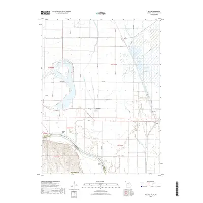
2017 Map of Big Lake
USGS Topo · Published 2017About this map
Big Lake serves as the central geographic feature of this Missouri riverfront landscape, surrounded by a dense network of residential streets such as Alpine Beach Dr, Lake Shore Dr, and Mobile Ln. This area of Holt County is defined by its complex hydrologic history, where the modern Missouri River channel creates the border with Nebraska, leaving behind remnant waterways and wetlands. Notable vestiges of the earlier drainage system include the Old Channel Tarkio River and Old Channel Little Tarkio Cr, which now feed into extensive managed wetlands like Mallard Marsh, Pintail Pool, and Snow Goose Pool.
Find a feature on this map
62 named features on this map. Tap any name to fly to it.
Don’t see what you’re looking for? This feature index may not catch every label — zoom into the map to look around manually.
Map Details
Editions of this 2017 Big Lake Map
This is the sole edition of this map. No revisions or reprints were ever made.
Other maps of this area

1885 · Atchison
USGS Topo · 1:125,000

1888 · Atchison
USGS Topo · 1:125,000

1893 · Atchison
USGS Topo · 1:125,000

1920 · Craig
USGS Topo · 1:62,500

1926 · Oregon
USGS Topo · 1:62,500

1926 · Maitland
USGS Topo · 1:62,500

1950 · Kansas City
USGS Topo · 1:250,000

1954 · Kansas City
USGS Topo · 1:250,000

1955 · Nebraska City
USGS Topo · 1:250,000

1956 · Kansas City
USGS Topo · 1:250,000