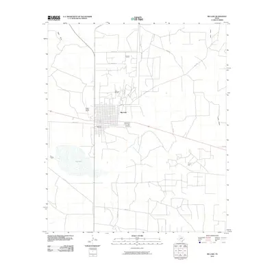
2010 Map of Big Lake
USGS Topo · Published 2010About this map
The town of Big Lake serves as the central hub of Reagan County, defined by its grid layout and the extensive petroleum infrastructure that surrounds it. This 2010 survey reveals a landscape where the oil industry is a primary driver of land use, marked by the John Scott Oil Field, Price Northwest Oil Field, and Price Oil Field. These fields are connected by a network of service roads such as Pembrook Rd and Rocker B Ln. Local geography is further characterized by the intermittent watercourses of Taylor Draw and Isaac Draw, which feed into the dry lake bed of Big Lake itself. For genealogists and local historians, the Glen Rest Cemetery is a significant landmark on the town's southern edge, while the Reagan County Airport reflects the area's ongoing importance as a regional transportation node for the energy sector.
Find a feature on this map
19 named features on this map. Tap any name to fly to it.
Don’t see what you’re looking for? This feature index may not catch every label — zoom into the map to look around manually.
Map Details
Editions of this 2010 Big Lake Map
This is the sole edition of this map. No revisions or reprints were ever made.
Other maps of this area

1920 · Big Lake
USGS Topo · 1:62,500

1922 · Big Lake
USGS Topo · 1:62,500

1928 · Rankin
USGS Topo · 1:125,000

1954 · San Angelo
USGS Topo · 1:250,000

1958 · San Angelo
USGS Topo · 1:250,000

1965 · San Angelo
USGS Topo · 1:250,000

1970 · South Mustang Draw SE
USGS Topo · 1:24,000
1970 · Texon SE
USGS Topo · 1:24,000

1970 · Gardener Draw
USGS Topo · 1:24,000
1970 · Divide Draw
USGS Topo · 1:24,000