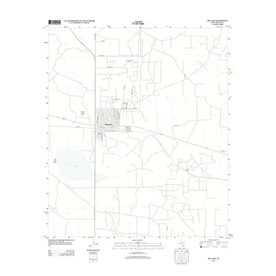
2013 Map of Big Lake
USGS Topo · Published 2013About this map
The West Texas oil industry and livestock ranching intersect in this detailed 2013 study of Reagan County. The town of Big Lake is the central hub, laid out on a grid that straddles the railroad corridor with thoroughfares like N Railroad St and S Railroad St. South of the residential core lies Glen Rest Cem, while the Reagan County Airport serves the regional aviation needs to the west.
Find a feature on this map
34 named features on this map. Tap any name to fly to it.
Don’t see what you’re looking for? This feature index may not catch every label — zoom into the map to look around manually.
Map Details
Editions of this 2013 Big Lake Map
This is the sole edition of this map. No revisions or reprints were ever made.
Other maps of this area

1920 · Big Lake
USGS Topo · 1:62,500

1922 · Big Lake
USGS Topo · 1:62,500

1928 · Rankin
USGS Topo · 1:125,000

1954 · San Angelo
USGS Topo · 1:250,000

1958 · San Angelo
USGS Topo · 1:250,000

1965 · San Angelo
USGS Topo · 1:250,000

1970 · South Mustang Draw SE
USGS Topo · 1:24,000
1970 · Texon SE
USGS Topo · 1:24,000

1970 · Gardener Draw
USGS Topo · 1:24,000
1970 · Divide Draw
USGS Topo · 1:24,000