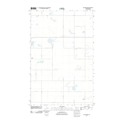
2011 Map of Big Meadow
USGS Topo · Published 2011About this map
Grong Cemetery and Stordahl Cemetery sit amidst the expansive prairie wetlands of Williams County, reflecting the early settlement history of this northern plains landscape. The topography is defined by numerous small water bodies and seasonal wetlands, most notably Helle Slough in the western reaches. A strict section-line grid of rural roads, including 75th St NW and 110th Ave NW, organizes the territory for agricultural use. In the southern portion of the quadrangle, Saint Olaf Cemetery provides another point of interest for genealogists tracing family roots in this rural community. The map illustrates a high-latitude drainage pattern where water collects in depressions rather than flowing through integrated stream networks, a characteristic feature of this glacial till plain.
Find a feature on this map
18 named features on this map. Tap any name to fly to it.
Don’t see what you’re looking for? This feature index may not catch every label — zoom into the map to look around manually.
Map Details
Editions of this 2011 Big Meadow Map
This is the sole edition of this map. No revisions or reprints were ever made.
Other maps of this area

1911 · Ray
USGS Topo · 1:125,000

1953 · Williston
USGS Topo · 1:250,000

1957 · Williston
USGS Topo · 1:250,000

1974 · Wildrose
USGS Topo · 1:24,000

1974 · Tom Berg Lake
USGS Topo · 1:24,000

1974 · Hamlet
USGS Topo · 1:24,000

1974 · McGregor
USGS Topo · 1:24,000
1974 · Bush Lake
USGS Topo · 1:24,000

1974 · Big Meadow
USGS Topo · 1:24,000

1978 · Temple
USGS Topo · 1:24,000