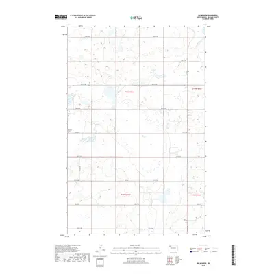
2017 Map of Big Meadow
USGS Topo · Published 2017About this map
Big Meadow dominates the central landscape of this Williams County quadrangle, a vast low-lying wetland area surrounded by a regular grid of section-line roads. The agricultural character of the region is punctuated by several small burial grounds that serve as vital links for family historians. These include Saint Olaf Cem in the southeastern corner, Grong Cem to the north, and Stordahl Cem along the western edge. The transportation network is defined by the intersection of north-south routes like Co Rd 19 and east-west corridors such as Co Hwy 19, which provide the primary access through these prairies. This 2017 survey reflects a modern era of mapping while preserving the names of local landmarks that have defined this rural township structure for generations.
Find a feature on this map
25 named features on this map. Tap any name to fly to it.
Don’t see what you’re looking for? This feature index may not catch every label — zoom into the map to look around manually.
Map Details
Editions of this 2017 Big Meadow Map
This is the sole edition of this map. No revisions or reprints were ever made.
Other maps of this area

1911 · Ray
USGS Topo · 1:125,000

1953 · Williston
USGS Topo · 1:250,000

1957 · Williston
USGS Topo · 1:250,000

1974 · Wildrose
USGS Topo · 1:24,000

1974 · Tom Berg Lake
USGS Topo · 1:24,000

1974 · Hamlet
USGS Topo · 1:24,000

1974 · McGregor
USGS Topo · 1:24,000
1974 · Bush Lake
USGS Topo · 1:24,000

1974 · Big Meadow
USGS Topo · 1:24,000

1978 · Temple
USGS Topo · 1:24,000