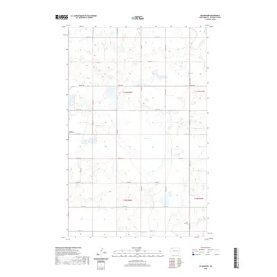
2020 Map of Big Meadow
USGS Topo · Published 2020About this map
Big Meadow dominates the central landscape of this Williams County prairie, which is defined by its glacial potholes and a vast network of wetlands. The topography is etched with a systematic grid of section lines and rural thoroughfares such as 81st St NW and 77th St NW, reflecting the enduring structure of the Public Land Survey System. For genealogists and local historians, the sheet is anchored by its rural burial grounds, including Stordahl Lutheran Cem in the west and Saint Olaf Cem in the southeast. These landmarks, along with Grong Cem, serve as the primary remaining indicators of the area's early Lutheran settlement patterns, marking a landscape that remains largely agricultural and sparsely populated.
Find a feature on this map
20 named features on this map. Tap any name to fly to it.
Don’t see what you’re looking for? This feature index may not catch every label — zoom into the map to look around manually.
Map Details
Editions of this 2020 Big Meadow Map
This is the sole edition of this map. No revisions or reprints were ever made.
Other maps of this area

1911 · Ray
USGS Topo · 1:125,000

1953 · Williston
USGS Topo · 1:250,000

1957 · Williston
USGS Topo · 1:250,000

1974 · Wildrose
USGS Topo · 1:24,000

1974 · Tom Berg Lake
USGS Topo · 1:24,000

1974 · Hamlet
USGS Topo · 1:24,000

1974 · McGregor
USGS Topo · 1:24,000
1974 · Bush Lake
USGS Topo · 1:24,000

1974 · Big Meadow
USGS Topo · 1:24,000

1978 · Temple
USGS Topo · 1:24,000