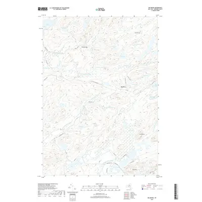
2019 Map of Big Moose
USGS Topo · Published 2019About this map
Big Moose and Woods Lake serve as the primary human hubs in this Adirondack landscape, where the seasonal rhythm of the Central Highlands is shaped by an intricate network of water and high peaks. The topography is dominated by significant elevations such as Twitchell Mtn and Slide Off Mtn, which frame a dense collection of glacial features including Silver Lake, Big Diamond Pond, and the expansive Stillwater Reservoir. The map reveals a specialized drainage pattern where the Twitchell Cr and Independence River wind through low-lying areas like Lyons Marsh and Polack Swamp. While modern roads like Rondaxe Rd and Carter Rd provide access, the area remains defined by its numerous small ponds—such as Silver Dollar Pond and Thirsty Pond—reflecting a region historically prized for its recreational camps and remote waterways.
Find a feature on this map
56 named features on this map. Tap any name to fly to it.
Don’t see what you’re looking for? This feature index may not catch every label — zoom into the map to look around manually.
Map Details
Editions of this 2019 Big Moose Map
This is the sole edition of this map. No revisions or reprints were ever made.
Other maps of this area

1901 · Old Forge
USGS Topo · 1:62,500

1903 · Big Moose
USGS Topo · 1:62,500

1912 · Number Four
USGS Topo · 1:62,500

1912 · Mc Keever
USGS Topo · 1:62,500

1915 · Number Four
USGS Topo · 1:62,500

1950 · Utica
USGS Topo · 1:250,000

1954 · Old Forge
USGS Topo · 1:62,500

1954 · Big Moose
USGS Topo · 1:62,500

1957 · Utica
USGS Topo · 1:250,000
1957 · Number Four
USGS Topo · 1:62,500