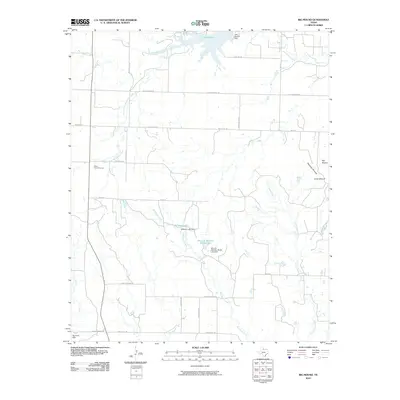
2010 Map of Big Mound
USGS Topo · Published 2010About this map
Medicine Mounds rise as prominent landmarks in this section of Hardeman County, anchoring a landscape defined by ranching heritage and water management. The terrain is marked by a network of drainage systems, including Wanderers Creek and Cottonwood Creek, which feed into engineered reservoirs such as Lake Pauline and Williams Lake. These water sources, often associated with specific families as seen with the Mrs J H Williams Ranch Lake, illustrate the vital role of private land improvements in this arid region.
Find a feature on this map
32 named features on this map. Tap any name to fly to it.
Don’t see what you’re looking for? This feature index may not catch every label — zoom into the map to look around manually.
Map Details
Editions of this 2010 Big Mound Map
This is the sole edition of this map. No revisions or reprints were ever made.
Other maps of this area

1927 · Quanah 3-a
USGS Topo · 1:48,000

1932 · Vivian
USGS Topo · 1:62,500

1955 · Lawton
USGS Topo · 1:250,000

1958 · Medicine Mound
USGS Topo · 1:62,500

1960 · Goodlett
USGS Topo · 1:62,500

1960 · Teacup Mountain
USGS Topo · 1:62,500

1960 · Quanah
USGS Topo · 1:62,500

1983 · Warrior Hollow
USGS Topo · 1:24,000

1983 · Big Mound
USGS Topo · 1:24,000
1983 · Margaret
USGS Topo · 1:24,000