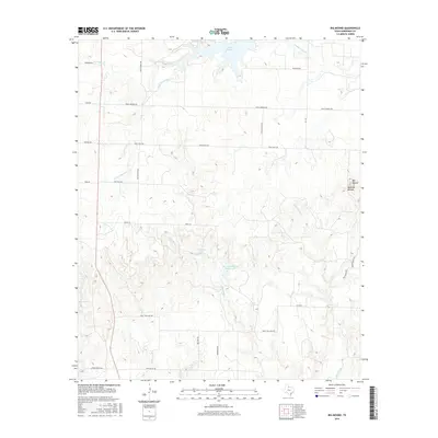
2016 Map of Big Mound
USGS Topo · Published 2016About this map
Medicine Mounds and the singular Big Mound anchor the eastern landscape of this Hardeman County region, rising above a network of seasonal drainages and ranch lands. The terrain is defined by the winding paths of Wanderers Creek and Cottonwood Creek, which feed into local catchments like Lake Pauline and Mrs J H Williams Ranch Lake. The map reveals a highly structured grid of rural infrastructure, where family-named routes such as Smith Ranch Rd, Hurst Williams Rd, and Brown Ranch Rd suggest long-standing land holdings. This 2016 survey reflects the modern intersection of private ranching interests and the natural watershed of the Texas Rolling Plains, where small, named bodies of water like Williams Lake are vital markers in an otherwise arid expanse of creek beds and draws.
Find a feature on this map
30 named features on this map. Tap any name to fly to it.
Don’t see what you’re looking for? This feature index may not catch every label — zoom into the map to look around manually.
Map Details
Editions of this 2016 Big Mound Map
This is the sole edition of this map. No revisions or reprints were ever made.
Other maps of this area

1927 · Quanah 3-a
USGS Topo · 1:48,000

1932 · Vivian
USGS Topo · 1:62,500

1955 · Lawton
USGS Topo · 1:250,000

1958 · Medicine Mound
USGS Topo · 1:62,500

1960 · Goodlett
USGS Topo · 1:62,500

1960 · Teacup Mountain
USGS Topo · 1:62,500

1960 · Quanah
USGS Topo · 1:62,500

1983 · Warrior Hollow
USGS Topo · 1:24,000

1983 · Big Mound
USGS Topo · 1:24,000
1983 · Margaret
USGS Topo · 1:24,000