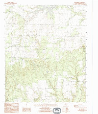
1990 Map of Big Mound
USGS Topo · Published 1995About this map
Medicine Mounds anchor this portion of Hardeman County, rising as prominent landmarks above the drainage systems of north-central Texas. The landscape is defined by the complex branching of Wanderers Creek, including its South Fork, which carves through the terrain toward Lake Pauline in the north. This provisional survey captures the area at a time when the natural topography remained the primary feature, with significant landmarks like Big Mound and Cedar Mound providing clear orientation points for researchers and local historians.
Find a feature on this map
10 named features on this map. Tap any name to fly to it.
Don’t see what you’re looking for? This feature index may not catch every label — zoom into the map to look around manually.
Map Details
Editions of this 1990 Big Mound Map
This is the sole edition of this map. No revisions or reprints were ever made.
Other maps of this area

1927 · Quanah 3-a
USGS Topo · 1:48,000

1932 · Vivian
USGS Topo · 1:62,500

1955 · Lawton
USGS Topo · 1:250,000

1958 · Medicine Mound
USGS Topo · 1:62,500

1960 · Goodlett
USGS Topo · 1:62,500

1960 · Teacup Mountain
USGS Topo · 1:62,500

1960 · Quanah
USGS Topo · 1:62,500

1983 · Warrior Hollow
USGS Topo · 1:24,000

1983 · Big Mound
USGS Topo · 1:24,000
1983 · Margaret
USGS Topo · 1:24,000