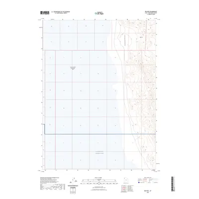
2023 Map of Big Pass
USGS Topo · Published 2023About this map
The Newfoundland Mountains rise sharply out of the salt flats in this isolated section of Box Elder County. This landform is defined by the prominent notch of Big Pass, which separates the northern reaches of the range. The landscape is split between natural topographic extremes and industrial-military utility, with the eastern slopes meeting the vast Newfoundland Evaporation Basin. To the south, the map indicates the northern boundary of the Utah Test and Training Range, a massive restricted area used for aerospace testing. The grid-like survey lines across the basin highlight the systematic management of this saline environment, where mineral extraction and military operations dominate a terrain otherwise void of permanent settlements or traditional infrastructure.
Find a feature on this map
4 named features on this map. Tap any name to fly to it.
Don’t see what you’re looking for? This feature index may not catch every label — zoom into the map to look around manually.
Map Details
Editions of this 2023 Big Pass Map
This is the sole edition of this map. No revisions or reprints were ever made.
Other maps of this area

1953 · Tooele
USGS Topo · 1:250,000

1954 · Brigham City
USGS Topo · 1:250,000

1955 · Tooele
USGS Topo · 1:250,000

1958 · Brigham City
USGS Topo · 1:250,000

1962 · Brigham City
USGS Topo · 1:250,000

1973 · Knolls 2 NW
USGS Topo · 1:24,000

1973 · Knolls 2 NE
USGS Topo · 1:24,000

1973 · Floating Island NE
USGS Topo · 1:24,000
1979 · Bonneville Salt Flats
USGS Topo · 1:100,000

1983 · Desert Peak
USGS Topo · 1:24,000