
1973 Map of Floating Island NE
USGS Topo · Published 1977About this map
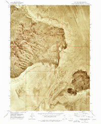
The Hill Air Force Range occupies a vast portion of this 1970s orthophotomap, illustrating the intersection of military operations and the stark Great Salt Lake Desert. The terrain is characterized by an expansive Mud Flat, a landscape that appears as a textured, nearly featureless expanse on this photographic survey. Rising abruptly from these saline flats is Floating Island, a distinct geological formation that serves as the map's primary landmark. Spanning the boundary between Box Elder Co and Tooele Co, the sheet provides a specialized view of this remote basin during a period of active military land use. The orthophoto format offers researchers a precise visual record of the ground surface, showing the subtle variations in the salt and mud deposits that define this unique Utah landscape.
Find a feature on this map
4 named features on this map. Tap any name to fly to it.
Don’t see what you’re looking for? This feature index may not catch every label — zoom into the map to look around manually.
Map Details
Editions of this 1973 Floating Island NE Map
This is the sole edition of this map. No revisions or reprints were ever made.
Other maps of this area

1953 · Tooele
USGS Topo · 1:250,000

1954 · Brigham City
USGS Topo · 1:250,000

1955 · Tooele
USGS Topo · 1:250,000

1958 · Brigham City
USGS Topo · 1:250,000

1962 · Brigham City
USGS Topo · 1:250,000

1973 · Floating Island SW
USGS Topo · 1:24,000

1973 · Knolls 2 NW
USGS Topo · 1:24,000

1973 · Floating Island SE
USGS Topo · 1:24,000

1973 · Knolls 2 SW
USGS Topo · 1:24,000
1973 · Floating Island
USGS Topo · 1:24,000