
1973 Map of Floating Island SE
USGS Topo · Published 1977About this map
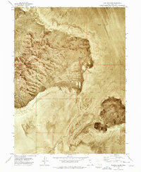
Hill Air Force Range dominates the northern portion of this orthophotomap, showing the stark intersection of military activity and the arid landscape of Tooele County during the early 1970s. The terrain is characterized almost entirely by an expansive Mud Flat, a featureless surface that highlights the isolation and specialized land use of the region. A survey Base Line crosses the lower third of the quadrangle, serving as a rare human-defined boundary in an area otherwise devoid of traditional settlements, roads, or structures. This 1973 field-checked study provides a precise visual record of the desert floor, where the natural playa surface was utilized for defense purposes within the wider Great Salt Lake Desert system.
Find a feature on this map
3 named features on this map. Tap any name to fly to it.
Don’t see what you’re looking for? This feature index may not catch every label — zoom into the map to look around manually.
Map Details
Editions of this 1973 Floating Island SE Map
This is the sole edition of this map. No revisions or reprints were ever made.
Other maps of this area

1953 · Tooele
USGS Topo · 1:250,000

1955 · Tooele
USGS Topo · 1:250,000

1973 · Arinosa
USGS Topo · 1:24,000

1973 · Floating Island SW
USGS Topo · 1:24,000

1973 · Arinosa NE
USGS Topo · 1:24,000

1973 · Knolls 2 NW
USGS Topo · 1:24,000

1973 · Barro
USGS Topo · 1:24,000

1973 · Floating Island NE
USGS Topo · 1:24,000

1973 · Knolls 2 SW
USGS Topo · 1:24,000
1973 · Floating Island
USGS Topo · 1:24,000