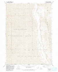
1991 Map of Big Pass
USGS Topo · Published 1991About this map
The Newfoundland Mountains rise sharply out of the vast, level expanse of the Great Salt Lake Desert in this 1991 survey. The landscape is defined by the stark contrast between the high relief of the range and the surrounding Newfoundland Evaporation Basin, where a dashed blue line at 4217 feet indicates the high-water elevation of the seasonal salt flats. This area, located near the border of Box Elder and Tooele counties, is heavily influenced by government operations, with a significant portion of the terrain falling within the Utah Test and Training Range North. A remote Landing Strip sits at the base of the mountains, while Big Pass provides a natural corridor through the northern heights. The map captures the isolation of this desert environment, marked primarily by mineral flats and the Military Reservation Boundary that limits public access.
Find a feature on this map
10 named features on this map. Tap any name to fly to it.
Don’t see what you’re looking for? This feature index may not catch every label — zoom into the map to look around manually.
Map Details
Editions of this 1991 Big Pass Map
This is the sole edition of this map. No revisions or reprints were ever made.
Other maps of this area

1953 · Tooele
USGS Topo · 1:250,000

1954 · Brigham City
USGS Topo · 1:250,000

1955 · Tooele
USGS Topo · 1:250,000

1958 · Brigham City
USGS Topo · 1:250,000

1962 · Brigham City
USGS Topo · 1:250,000

1973 · Knolls 2 NW
USGS Topo · 1:24,000

1973 · Knolls 2 NE
USGS Topo · 1:24,000

1973 · Floating Island NE
USGS Topo · 1:24,000
1979 · Bonneville Salt Flats
USGS Topo · 1:100,000

1983 · Desert Peak
USGS Topo · 1:24,000